1960s Maps of Wiser Township, North Dakota
Explore 5 historic maps of Wiser Township from the 1960s. These maps offer a rare glimpse into what life looked like during the 1960s — showing old roads, neighborhoods, homes, and landmarks that have changed or disappeared over time.
Whether you're researching your family's past, planning a metal detecting trip, or studying how Wiser Township's landscape evolved across the 1960s, these high-resolution maps are a powerful tool for exploring the history of this region.
- Focus on a specific era: All maps on this page are from the 1960s, giving you a focused view of this time period.
- See what’s changed: Compare century-old streets, trails, and buildings to today's modern landscape using overlays and satellite layers.
- Research with precision: Use these maps for genealogy, historical research, land use analysis, or educational projects.
- View, download, or print: Maps are fully viewable online in high resolution, and can be downloaded or printed for your own records.
Start exploring Wiser Township's history through authentic maps from the 1960s. This is your window into the past.
Wiser Township, ND maps
(5)- 1963 Map of Georgetown, 1964 Print
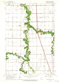 1963 Georgetown1964 Print · USGSThe Red River Valley's winding borderlands are captured here in the early sixties, showing the fertile divide between Minnesota and North Dakota. Researchers can trace the paths of the Great Northern railroad and locate community sites like Osterdalen Ch and Osterdalen Cem.
 - 1963 Map of Argusville, 1964 Print
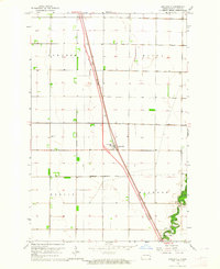 1963 Argusville1964 Print · USGSCass County agriculture and infrastructure intersect during the early sixties as a new rail line changes the prairie landscape. Genealogists and local historians can trace the Argusville boundaries, the High Sch, and the Argusville Cem.2 unique versions available
 - 1963 Map of Perley, 1964 Print
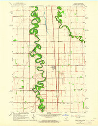 1963 Perley1964 Print · USGSThe Red River Valley at the Minnesota border comes into focus during the early sixties, showing the tight meanders of the Red River and Wild Rice River. Trace local history through the Great Northern rail stops, Perley townsite, and Kirkebo Cem.2 unique versions available
 - 1963 Map of Gardner, 1964 Print
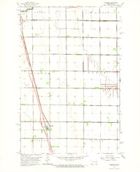 1963 Gardner1964 Print · USGSThe Red River Valley prairie is captured in the early sixties at the border of Traill County and Cass County. Researchers can trace rail history and land use through the Great Northern line and the townships of Kinyon and Noble.
 - 1966 Map of Grand Forks
 1966 Grand Forks1966 Print · USGSThe Red River Valley in the mid-sixties shows a landscape shaped by rail-line commerce and complex water management. Genealogists and historians can trace rail-side towns like Emerado and Hunter or locate rural landmarks like the Pleasant View Church.
End of results
Showing maps 1-5 of 5
Top cities near Wiser Township
- Fargo historical maps
- West Fargo historical maps
- Moorhead historical maps
- Dilworth historical maps
- Harwood historical maps
- Mapleton historical maps
See more
Frequently asked questions
- What are the different types of historical maps available for Wiser Township?
- What is the oldest map of Wiser Township?
- Where can I purchase historical maps of Wiser Township for my home or office?
- Where can I download high-res historical maps of Wiser Township?
- Are there historical topographic maps available for Wiser Township?
- Is there historical aerial imagery available for Wiser Township?
- Where are historical maps of Wiser Township sourced from?