1900s (20th Century) Maps of Killdeer, North Dakota
Explore 8 historic maps of Killdeer from the 1900s (20th Century). These maps offer a rare glimpse into what life looked like during the 1900s — showing old roads, neighborhoods, homes, and landmarks that have changed or disappeared over time.
Whether you're researching your family's past, planning a metal detecting trip, or studying how Killdeer's landscape evolved across the 1900s, these high-resolution maps are a powerful tool for exploring the history of this region.
- Focus on a specific era: All maps on this page are from the 1900s, giving you a focused view of this time period.
- See what’s changed: Compare century-old streets, trails, and buildings to today's modern landscape using overlays and satellite layers.
- Research with precision: Use these maps for genealogy, historical research, land use analysis, or educational projects.
- View, download, or print: Maps are fully viewable online in high resolution, and can be downloaded or printed for your own records.
Start exploring Killdeer's history through authentic maps from the 1900s. This is your window into the past.
Killdeer, ND maps
(8)- 1953 Map of Watford City, 1968 Print
 1953 Watford City1968 Print · USGSNorth Dakota's badlands and the Missouri River basin are captured here during the 1950s and 60s as the Garrison Dam changed the landscape. Researchers can trace old rail lines like the Great Northern or find rural outposts such as Grassy Butte and Halliday.3 unique versions available
 - 1957 Map of Watford City
 1957 Watford City1957 Print · USGSWestern North Dakota's landscape is captured here during the mid-fifties as the Missouri River valley undergoes massive change following the creation of Garrison Reservoir. Genealogists and historians can trace dozens of rural schools like Divide School and early settlements such as Arnegard and Grassy Butte.
 - 1967 Map of Watford City
 1967 Watford City1967 Print · USGSWestern North Dakota is captured during a period of landscape transformation as the Missouri River valley was reshaped by the new Garrison Reservoir. Genealogists and local historians can trace the foundations of Watford City, find the Elkhorn Ranch Site, or locate rural landmarks like Ziner Butte and Grassy Butte.
 - 1970 Map of Dunn Center NW, 1973 Print
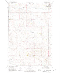
 1970 Dunn Center NW1973 Print · USGSDunn County, North Dakota, is captured here in the early seventies, showing a landscape defined by ranching terrain and rail infrastructure. Genealogists and researchers can locate Peace Cem or trace the Burlington Northern line as it follows the banks of Spring Creek.
 - 1973 Map of Lake Ilo, 1978 Print
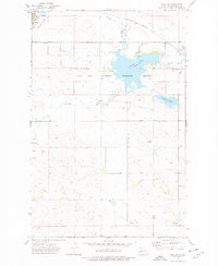 1973 Lake Ilo1978 Print · USGSDunn County is captured here in the 1970s, as the prairie landscape surrounds the waters of the Lake Ilo National Wildlife Refuge. Researchers can trace old family burial grounds like Mormannia Cem, follow the Burlington Northern rail line, or locate the historic center of Dunn Center.
 - 1974 Map of Killdeer, 1976 Print
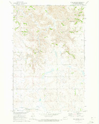
 1974 Killdeer1976 Print · USGSWestern North Dakota's ranching and rail country comes into focus in the mid-seventies, showing the prairie landscape before modern energy booms. Trace the Burlington Northern line through Dodge, Werner, and Golden Valley, or locate family landmarks near Manning and New Hradec.
 - 1974 Map of Killdeer, 1977 Print
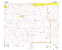
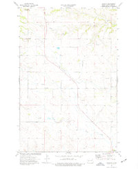
 1974 Killdeer1977 Print · USGSIn the mid-1970s, the town of Killdeer stood as a vital rail and ranching terminus in the North Dakota badlands. Genealogists and historians can trace the local rail spur of the B N, find the Killdeer Cem, and locate early industrial sites like the Scoria Pit.
 - 1974 Map of Oakdale, 1977 Print
 1974 Oakdale1977 Print · USGSDunn County at the mid-point of the 1970s shows a transition from high-mountain foothills to a prairie creek network. Genealogists and local historians can trace the community around Oakdale, locate the Oakdale Cem, and see the early layout of Killdeer.
End of results
Showing maps 1-8 of 8
Top cities near Killdeer
Frequently asked questions
- What are the different types of historical maps available for Killdeer?
- What is the oldest map of Killdeer?
- Where can I purchase historical maps of Killdeer for my home or office?
- Where can I download high-res historical maps of Killdeer?
- Are there historical topographic maps available for Killdeer?
- Is there historical aerial imagery available for Killdeer?
- Where are historical maps of Killdeer sourced from?