1960s Maps of Eddy County, North Dakota
Explore 7 historic maps of Eddy County from the 1960s. These maps offer a rare glimpse into what life looked like during the 1960s — showing old roads, neighborhoods, homes, and landmarks that have changed or disappeared over time.
Whether you're researching your family's past, planning a metal detecting trip, or studying how Eddy County's landscape evolved across the 1960s, these high-resolution maps are a powerful tool for exploring the history of this region.
- Focus on a specific era: All maps on this page are from the 1960s, giving you a focused view of this time period.
- See what’s changed: Compare century-old streets, trails, and buildings to today's modern landscape using overlays and satellite layers.
- Research with precision: Use these maps for genealogy, historical research, land use analysis, or educational projects.
- View, download, or print: Maps are fully viewable online in high resolution, and can be downloaded or printed for your own records.
Start exploring Eddy County's history through authentic maps from the 1960s. This is your window into the past.
Eddy County, ND maps
(7)- 1961 Map of Lake Coe, 1962 Print
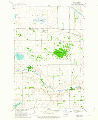
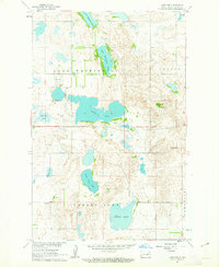 1961 Lake Coe1962 Print · USGSEddy County in the early sixties reveals a landscape of isolated farmsteads and prairie wetlands centered on Lake Coe. Genealogists and local historians can locate early educational hubs like School No 9 and School No 3 among the many lakes.2 unique versions available
 - 1961 Map of McHenry, 1963 Print
 1961 McHenry1963 Print · USGSMcHenry and the surrounding prairie of Foster and Eddy Counties are captured here in the early sixties as a settled agricultural and rail landscape. Researchers can trace the Northern Pacific line into the village of McHenry and locate the historic Bethlehem Cem.
 - 1961 Map of Juanita, 1963 Print
 1961 Juanita1963 Print · USGSFoster County prairie life and rail transport are captured here in the early sixties as the railroad era still shaped the plains. Researchers can locate the settlement of Juanita and trace the Great Northern tracks past Juanita Lake and Cherry Lake.
 - 1961 Map of Johnson Lake, 1963 Print
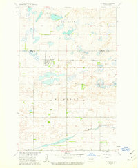
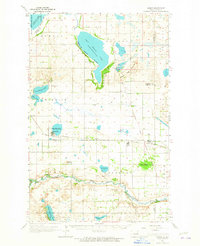
 1961 Johnson Lake1963 Print · USGSPrairie potholes and the Johnson Lake National Wildlife Refuge define this rural Eddy County landscape in the early sixties. Genealogists can locate Gethsemane Ch, its nearby Cem, and the Community Hall among the farms of Colvin and Paradise.2 unique versions available
 - 1962 Map of Hamar, 1964 Print
 1962 Hamar1964 Print · USGSEddy and Benson counties at the start of the 1960s reveal a landscape of prairie townships and river bends. Genealogists and local historians can trace the Great Northern rail line through Hamar or locate family sites near Sigdal Ch and Battle Lake.
 - 1962 Map of Warwick, 1964 Print
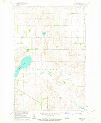
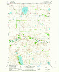 1962 Warwick1964 Print · USGSThe Benson and Eddy County line in the early sixties is dominated by the Sheyenne River and the small rail-town of Warwick. Local researchers can trace family roots at Warwick Cem or locate the historic Great Northern rail route and the Indian Reservation Boundary.
 - 1962 Map of Hamar, 1965 Print
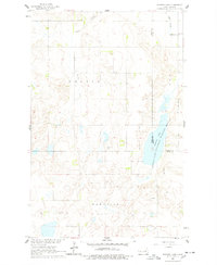
 1962 Hamar1965 Print · USGSBenson and Ramsey counties are depicted in the early sixties as a network of lakeside settlements and prairie rail lines. You can locate rural schoolhouses and family landmarks like Sigdal Ch, the Indian Mound, and cemeteries in Warwick and Hamar.
End of results
Showing maps 1-7 of 7
Top cities of Eddy County
Frequently asked questions
- What are the different types of historical maps available for Eddy County?
- What is the oldest map of Eddy County?
- Where can I purchase historical maps of Eddy County for my home or office?
- Where can I download high-res historical maps of Eddy County?
- Are there historical topographic maps available for Eddy County?
- Is there historical aerial imagery available for Eddy County?
- Where are historical maps of Eddy County sourced from?