1990s Maps of Pearl Township, North Dakota
Explore 3 historic maps of Pearl Township from the 1990s. These maps offer a rare glimpse into what life looked like during the 1990s — showing old roads, neighborhoods, homes, and landmarks that have changed or disappeared over time.
Whether you're researching your family's past, planning a metal detecting trip, or studying how Pearl Township's landscape evolved across the 1990s, these high-resolution maps are a powerful tool for exploring the history of this region.
- Focus on a specific era: All maps on this page are from the 1990s, giving you a focused view of this time period.
- See what’s changed: Compare century-old streets, trails, and buildings to today's modern landscape using overlays and satellite layers.
- Research with precision: Use these maps for genealogy, historical research, land use analysis, or educational projects.
- View, download, or print: Maps are fully viewable online in high resolution, and can be downloaded or printed for your own records.
Start exploring Pearl Township's history through authentic maps from the 1990s. This is your window into the past.
Pearl Township, ND maps
(3)- 1997 Map of Trotters SE, 2001 Print
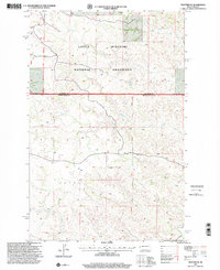 1997 Trotters SE2001 Print · USGSGolden Valley and McKenzie counties are shown in the late nineties, documenting a sparse ranching and energy landscape. Genealogists and researchers can locate landmarks like Trotter, Flat Rock Butte, and industrial markers such as a PIPELINE and Drill Hole.
 - 1997 Map of Hootowl Creek East, 2001 Print
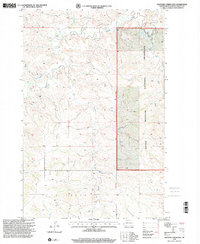 1997 Hootowl Creek East2001 Print · USGSGolden Valley County in the late nineties remains a landscape of open prairie and managed range. Genealogists and historians can trace the drainage patterns of Hootowl Creek and Beaver Creek or locate landmarks within the Little Missouri National Grassland.
 - 1997 Map of Trotters, 2001 Print
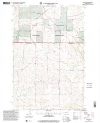 1997 Trotters2001 Print · USGSGolden Valley County ranching and badlands topography are preserved here in the late 1990s. Genealogists and historians can locate remote landmarks like Gorrell Ranch, the South Side Cem, and the small settlement of Trotters.
End of results
Showing maps 1-3 of 3
Top neighborhoods of Pearl Township
Frequently asked questions
- What are the different types of historical maps available for Pearl Township?
- What is the oldest map of Pearl Township?
- Where can I purchase historical maps of Pearl Township for my home or office?
- Where can I download high-res historical maps of Pearl Township?
- Are there historical topographic maps available for Pearl Township?
- Is there historical aerial imagery available for Pearl Township?
- Where are historical maps of Pearl Township sourced from?