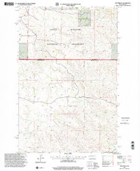
1997 Map of Trotters SE
USGS Topo · Published 2001About this map
The Little Missouri National Grassland dominates this corner of North Dakota, where the McKenzie and Golden Valley county line cuts across a landscape defined by intermittent drainage and surveying monuments. The map documents a sparsely populated ranching and energy landscape in the late 20th century, centered on the Trotter locale. The terrain is marked by distinct features such as Flat Rock Butte and the broad region of Pearl. Waterways like Porcupine Creek and Horse Creek weave through the grasslands, which are also crossed by a Pipeline and significant geographical markers including the Sixteenth Guide Meridian West and the Eleventh Standard Parallel North. Small-scale features such as a Drill Hole and various bench marks like BM 2513 provide precise points of reference for researchers and local historians studying the physical and industrial development of the high plains.
Find a feature on this map
17 named features on this map. Tap any name to fly to it.
Don’t see what you’re looking for? This feature index may not catch every label — zoom into the map to look around manually.
Map Details
Editions of this 1997 Trotters SE Map
This is the sole edition of this map. No revisions or reprints were ever made.
Other maps of this area

1953 · Watford City
USGS Topo · 1:250,000

1957 · Watford City
USGS Topo · 1:250,000

1967 · Watford City
USGS Topo · 1:250,000

1970 · Eagle Draw
USGS Topo · 1:24,000

1974 · Hootowl Creek West
USGS Topo · 1:24,000

1974 · Trotters SE
USGS Topo · 1:24,000

1974 · Trotters
USGS Topo · 1:24,000

1974 · Roosevelt Creek West
USGS Topo · 1:24,000
1974 · Squaw Gap
USGS Topo · 1:24,000
1974 · Cinnamon Creek
USGS Topo · 1:24,000