1980s Maps of Almont, North Dakota
Explore 3 historic maps of Almont from the 1980s. These maps offer a rare glimpse into what life looked like during the 1980s — showing old roads, neighborhoods, homes, and landmarks that have changed or disappeared over time.
Whether you're researching your family's past, planning a metal detecting trip, or studying how Almont's landscape evolved across the 1980s, these high-resolution maps are a powerful tool for exploring the history of this region.
- Focus on a specific era: All maps on this page are from the 1980s, giving you a focused view of this time period.
- See what’s changed: Compare century-old streets, trails, and buildings to today's modern landscape using overlays and satellite layers.
- Research with precision: Use these maps for genealogy, historical research, land use analysis, or educational projects.
- View, download, or print: Maps are fully viewable online in high resolution, and can be downloaded or printed for your own records.
Start exploring Almont's history through authentic maps from the 1980s. This is your window into the past.
Almont, ND maps
(3)- 1980 Map of Almont East
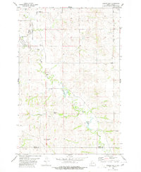 1980 Almont East1980 Print · USGSThe town of Almont and the surrounding Morton County prairie are captured here in 1980. Researchers can trace the Old Railroad Grade and locate local landmarks like the Rodeo Ground, Almont Cem, and Antelope Butte.
 - 1980 Map of Almont West
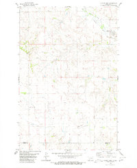 1980 Almont West1980 Print · USGSNorth Dakota's rural heartland is documented here in the late seventies, showing the landscape around the Morton and Grant county line. Researchers can trace the layout of Almont and locate family landmarks like the Ramsland Hills or scattered Well sites.
 - 1980 Map of Glen Ullin
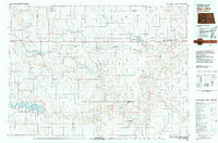 1980 Glen Ullin1980 Print · USGSMorton County in the late seventies is captured here, centered on the railroad towns of Glen Ullin and New Salem. Local historians can trace early settlements like Bluegrass and Almont or the growth of the Heart Butte Reservoir and regional Strip Mine operations.
End of results
Showing maps 1-3 of 3
Top cities near Almont
Frequently asked questions
- What are the different types of historical maps available for Almont?
- What is the oldest map of Almont?
- Where can I purchase historical maps of Almont for my home or office?
- Where can I download high-res historical maps of Almont?
- Are there historical topographic maps available for Almont?
- Is there historical aerial imagery available for Almont?
- Where are historical maps of Almont sourced from?