1900s (20th Century) Maps of Mandan, North Dakota
Explore 9 historic maps of Mandan from the 1900s (20th Century). These maps offer a rare glimpse into what life looked like during the 1900s — showing old roads, neighborhoods, homes, and landmarks that have changed or disappeared over time.
Whether you're researching your family's past, planning a metal detecting trip, or studying how Mandan's landscape evolved across the 1900s, these high-resolution maps are a powerful tool for exploring the history of this region.
- Focus on a specific era: All maps on this page are from the 1900s, giving you a focused view of this time period.
- See what’s changed: Compare century-old streets, trails, and buildings to today's modern landscape using overlays and satellite layers.
- Research with precision: Use these maps for genealogy, historical research, land use analysis, or educational projects.
- View, download, or print: Maps are fully viewable online in high resolution, and can be downloaded or printed for your own records.
Start exploring Mandan's history through authentic maps from the 1900s. This is your window into the past.
Mandan, ND maps
(9)- 1907 Map of Bismarck
 1907 Bismarck1907 Print · USGSThe Missouri River corridor at the turn of the century shows North Dakota's capital and rail hubs in their formative years. Researchers can trace early land divisions and transport routes like the Fort Yates Stage Road and landmarks such as Fort Lincoln or St Anthony.2 unique versions available
 - 1950 Map of Bismarck
 1950 Bismarck1950 Print · USGSBismarck and Mandan face one another across the Missouri River at a time when the capital's historic military roots and modern rail infrastructure were both clearly visible. Genealogists and historians can trace the State Prison Farm, Fraine Barracks, and old Indian Mounds.
 - 1951 Map of Bismarck
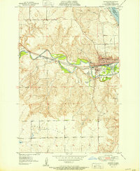
 1951 Bismarck1951 Print · USGSBismarck and Mandan sit at the heart of the Missouri River valley at mid-century, just as the post-war era began to reshape the North Dakota capital. Genealogists and local historians can trace legacy landmarks like St Marys Cem, the Great Plains Experiment Station, and numerous rural schoolhouses such as Sunny Sch.
 - 1951 Map of Mandan
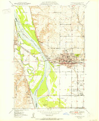
 1951 Mandan1951 Print · USGSMid-century Mandan and the Missouri River floodplain come alive in this detailed mid-century survey. Genealogists and local historians can trace the foundations of the community through the State Training School, the rural Sunny Sch, and the high-elevation Custer Flats.
 - 1954 Map of Bismarck, 1967 Print
 1954 Bismarck1967 Print · USGSBismarck and the Missouri River basin are shown in the mid-1960s as the Oahe Reservoir reshaped the valley. Genealogists can trace family-named landmarks like Dog Tooth Buttes and small prairie settlements such as Fort Yates, Selfridge, and Brisbane.2 unique versions available
 - 1958 Map of Bismarck
 1958 Bismarck1958 Print · USGSCentral North Dakota in the late fifties is defined by the Missouri River and the sprawling Standing Rock Indian Reservation. Genealogists and historians can trace rail-line outposts like Sedalia Siding or explore local landmarks like Saint Anthony and Fort Lincoln State Park/Museum.
 - 1962 Map of Bismarck, 1964 Print
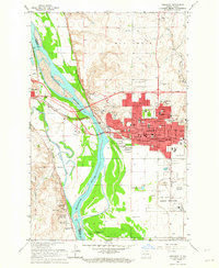 1962 Bismarck1964 Print · USGSBismarck and Mandan face each other across the Missouri River in the early 1960s during a period of significant capital expansion. Trace the historical roots of the region at the Fort Lincoln Historic Site Ruins, the Capitol grounds, and the Northern Pacific rail yards.3 unique versions available
 - 1962 Map of Mandan, 1964 Print
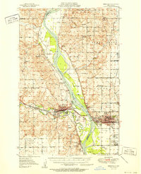
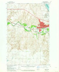 1962 Mandan1964 Print · USGSMandan was a bustling rail and energy hub in the early sixties where the Heart and Missouri rivers meet. Genealogists and historians can trace the town's growth through its many neighborhood institutions, including St Joseph Sch, the State Training School, and Custer Sch No 1.2 unique versions available
 - 1979 Map of Bismarck, 1980 Print
 1979 Bismarck1980 Print · USGSBismarck and Mandan sit at the heart of this late-century North Dakota survey, where the Missouri River flows past historic frontier outposts. Trace the old Soo Line rail corridors or locate family landmarks near St Anthony, Fort Rice, and Custer Flats.
End of results
Showing maps 1-9 of 9
Top cities near Mandan
Top neighborhoods of Mandan
Frequently asked questions
- What are the different types of historical maps available for Mandan?
- What is the oldest map of Mandan?
- Where can I purchase historical maps of Mandan for my home or office?
- Where can I download high-res historical maps of Mandan?
- Are there historical topographic maps available for Mandan?
- Is there historical aerial imagery available for Mandan?
- Where are historical maps of Mandan sourced from?