1960s Maps of Aneta, North Dakota
Explore 3 historic maps of Aneta from the 1960s. These maps offer a rare glimpse into what life looked like during the 1960s — showing old roads, neighborhoods, homes, and landmarks that have changed or disappeared over time.
Whether you're researching your family's past, planning a metal detecting trip, or studying how Aneta's landscape evolved across the 1960s, these high-resolution maps are a powerful tool for exploring the history of this region.
- Focus on a specific era: All maps on this page are from the 1960s, giving you a focused view of this time period.
- See what’s changed: Compare century-old streets, trails, and buildings to today's modern landscape using overlays and satellite layers.
- Research with precision: Use these maps for genealogy, historical research, land use analysis, or educational projects.
- View, download, or print: Maps are fully viewable online in high resolution, and can be downloaded or printed for your own records.
Start exploring Aneta's history through authentic maps from the 1960s. This is your window into the past.
Aneta, ND maps
(3)- 1966 Map of Grand Forks
 1966 Grand Forks1966 Print · USGSThe Red River Valley in the mid-sixties shows a landscape shaped by rail-line commerce and complex water management. Genealogists and historians can trace rail-side towns like Emerado and Hunter or locate rural landmarks like the Pleasant View Church.
 - 1967 Map of Aneta, 1969 Print
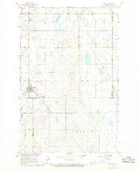 1967 Aneta1969 Print · USGSAneta and the surrounding prairie townships are captured here in the late 1960s at the meeting point of Nelson, Griggs, and Steele counties. Genealogists can trace family roots through landmarks like Silent Hill Cemetery, Norway Church, and the Great Northern rail line.
 - 1967 Map of Kloten, 1969 Print
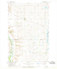 1967 Kloten1969 Print · USGSNelson and Griggs counties come together on the North Dakota prairie during the late 1960s, centered on the railroad town of Kloten. Trace the diagonal route of the Great Northern railway past Valley Grove Cem and the distinctive Pilot Mound.
End of results
Showing maps 1-3 of 3
Top cities near Aneta
- Cooperstown historical maps
- Finley historical maps
- McVille historical maps
- Sharon historical maps
- Logan Center historical maps
Frequently asked questions
- What are the different types of historical maps available for Aneta?
- What is the oldest map of Aneta?
- Where can I purchase historical maps of Aneta for my home or office?
- Where can I download high-res historical maps of Aneta?
- Are there historical topographic maps available for Aneta?
- Is there historical aerial imagery available for Aneta?
- Where are historical maps of Aneta sourced from?