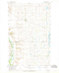
1967 Map of Kloten
USGS Topo · Published 1969About this map
The Great Northern railroad tracks cut a diagonal path across this prairie landscape, anchoring the small settlement of Kloten. Situated in a region defined by its glacial hydrology, the area is dotted with numerous wetlands and depressions, including Omlid Slough, Solberg Slough, and Hillestand Lake. To the southwest, the terrain descends toward the winding Sheyenne River valley, where the prominent Pilot Mound rises above the riverbanks. This 1960s survey documents the rural character of the Nelson and Griggs County border, showing a network of section roads connecting isolated homesteads to local landmarks like Valley Grove Cem. The landscape reflects a mid-century agricultural economy, supported by the railway and scattered industrial sites such as the Gravel Pits found near the river and along the township lines.
Find a feature on this map
17 named features on this map. Tap any name to fly to it.
Don’t see what you’re looking for? This feature index may not catch every label — zoom into the map to look around manually.
Map Details
Editions of this 1967 Kloten Map
This is the sole edition of this map. No revisions or reprints were ever made.
Other maps of this area

1939 · Niagara
USGS Topo · 1:62,500

1942 · McVille
USGS Topo · 1:62,500

1952 · Grand Forks
USGS Topo · 1:250,000

1952 · New Rockford
USGS Topo · 1:250,000

1956 · New Rockford
USGS Topo · 1:250,000

1956 · Grand Forks
USGS Topo · 1:250,000

1961 · Kloten NW
USGS Topo · 1:24,000

1961 · Jessie
USGS Topo · 1:24,000
1961 · McVille
USGS Topo · 1:24,000

1963 · Niagara SW
USGS Topo · 1:24,000