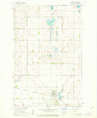
1961 Map of McVille
USGS Topo · Published 1963About this map
The town of McVille serves as the focal point of this Nelson County landscape during the early 1960s, situated at a junction of rail and road transport. The Great Northern railway cuts through the southern reaches of the area, supporting the agricultural and transport needs of the surrounding townships, including Central, Hamlin, and Field. The terrain is defined by a glacial pothole topography, where numerous wetlands such as Olsen Slough, Bartlett Slough, and Dahl Slough dot the prairie.
Find a feature on this map
20 named features on this map. Tap any name to fly to it.
Don’t see what you’re looking for? This feature index may not catch every label — zoom into the map to look around manually.
Map Details
Editions of this 1961 McVille Map
This is the sole edition of this map. No revisions or reprints were ever made.
Other maps of this area

1930 · Pekin
USGS Topo · 1:62,500

1942 · McVille
USGS Topo · 1:62,500

1951 · Pekin NE
USGS Topo · 1:24,000

1951 · Pekin
USGS Topo · 1:24,000

1951 · Pekin
USGS Topo · 1:62,500

1952 · New Rockford
USGS Topo · 1:250,000

1956 · New Rockford
USGS Topo · 1:250,000

1961 · Kloten NW
USGS Topo · 1:24,000

1961 · Binford NE
USGS Topo · 1:24,000
1963 · McVille SE
USGS Topo · 1:24,000