1960s Maps of Mooreton Township, North Dakota
Explore 4 historic maps of Mooreton Township from the 1960s. These maps offer a rare glimpse into what life looked like during the 1960s — showing old roads, neighborhoods, homes, and landmarks that have changed or disappeared over time.
Whether you're researching your family's past, planning a metal detecting trip, or studying how Mooreton Township's landscape evolved across the 1960s, these high-resolution maps are a powerful tool for exploring the history of this region.
- Focus on a specific era: All maps on this page are from the 1960s, giving you a focused view of this time period.
- See what’s changed: Compare century-old streets, trails, and buildings to today's modern landscape using overlays and satellite layers.
- Research with precision: Use these maps for genealogy, historical research, land use analysis, or educational projects.
- View, download, or print: Maps are fully viewable online in high resolution, and can be downloaded or printed for your own records.
Start exploring Mooreton Township's history through authentic maps from the 1960s. This is your window into the past.
Mooreton Township, ND maps
(4)- 1960 Map of Mooreton West, 1961 Print
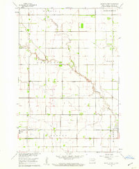 1960 Mooreton West1961 Print · USGSRichland County at the start of the 1960s shows a landscape of precise township grids and prairie waterways. Genealogists and local researchers can trace the rail corridor of the Northern Pacific and locate rural landmarks like Antelope Sch and Antelope Cem.2 unique versions available
 - 1960 Map of Mooreton East, 1961 Print
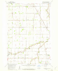 1960 Mooreton East1961 Print · USGSRichland County's agricultural heartland is captured here during the mid-twentieth century, showing a landscape defined by rail lines and section roads. Genealogists and local historians can trace the foundations of Mooreton and Farmington or locate rural landmarks like St Paul Ch and Wahpeton School No 5.2 unique versions available
 - 1964 Map of Mantador, 1965 Print
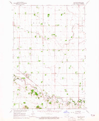 1964 Mantador1965 Print · USGSRichland County's agricultural heartland is documented here in the mid-1960s, showing the intersection of rail and river life. Researchers can trace family roots through Mantador and Bayne, or locate historical sites like St Johns Ch and Calvary Cem.
 - 1964 Map of Great Bend, 1965 Print
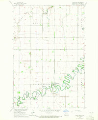 1964 Great Bend1965 Print · USGSRichland County agriculture and river life are captured here in the mid-1960s, centered on the tight meanders of the Wild Rice River. Researchers can trace the Northern Pacific rail corridor and locate family sites near Great Bend or Trinity Cem.2 unique versions available
End of results
Showing maps 1-4 of 4
Top cities near Mooreton Township
- Wahpeton historical maps
- Breckenridge historical maps
- Hankinson historical maps
- Fairmount historical maps
- Abercrombie historical maps
- Mooreton historical maps
See more
Frequently asked questions
- What are the different types of historical maps available for Mooreton Township?
- What is the oldest map of Mooreton Township?
- Where can I purchase historical maps of Mooreton Township for my home or office?
- Where can I download high-res historical maps of Mooreton Township?
- Are there historical topographic maps available for Mooreton Township?
- Is there historical aerial imagery available for Mooreton Township?
- Where are historical maps of Mooreton Township sourced from?