
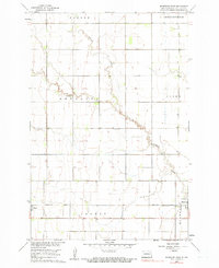
1960 Map of Mooreton West
USGS Topo · Published 1961About this map
Antelope Creek meanders across this southeastern North Dakota landscape, carving a serpentine path through the townships of Abercrombie, Ibsen, and Antelope. Published by the Geological Survey as part of a Missouri River Basin development program, the map documents a strictly organized agricultural grid defined by section lines and field boundaries. The small settlements of Barney and Mooreton serve as the primary hubs, situated along the Northern Pacific railroad line that cuts through the southern portion of the quadrangle.
Find a feature on this map
11 named features on this map. Tap any name to fly to it.
Don’t see what you’re looking for? This feature index may not catch every label — zoom into the map to look around manually.
Map Details
Editions of this 1960 Mooreton West Map
2 editions found
Other maps of this area

1904 · Wahpeton
USGS Topo · 1:125,000

1907 · Wyndmere
USGS Topo · 1:125,000

1953 · Fargo
USGS Topo · 1:250,000

1956 · Fargo
USGS Topo · 1:250,000

1959 · Wyndmere NE
USGS Topo · 1:24,000

1959 · Mooreton NW
USGS Topo · 1:24,000

1960 · Galchutt
USGS Topo · 1:24,000

1960 · Wyndmere SE
USGS Topo · 1:24,000

1960 · Mooreton East
USGS Topo · 1:24,000

1964 · Mantador
USGS Topo · 1:24,000