
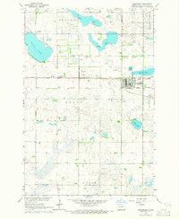
1964 Map of Kreiser Lake
USGS Topo · Published 1965About this map
The Wild Rice River winds through the northern townships of Wyndmere and Anton, carving a distinct riparian corridor through the North Dakota prairie. This mid-1960s survey, conducted for the Department of the Interior’s Missouri River Basin development program, shows a rural landscape defined by township boundaries and the water-driven geography of the Red River Valley. In the southern half of the map, Dexter and Liberty Grove townships are dotted with numerous small wetlands and basins, including the namesake Kreiser Lake. The agrarian character of the area is further evidenced by a scattered Gravel Pit and the presence of the Elk Creek Cem near Elk Creek, providing valuable points of interest for genealogists and local historians tracking family sites in Richland County.
Find a feature on this map
9 named features on this map. Tap any name to fly to it.
Don’t see what you’re looking for? This feature index may not catch every label — zoom into the map to look around manually.
Map Details
Editions of this 1964 Kreiser Lake Map
This is the sole edition of this map. No revisions or reprints were ever made.
Other maps of this area

1907 · Wyndmere
USGS Topo · 1:125,000

1953 · Fargo
USGS Topo · 1:250,000

1956 · Fargo
USGS Topo · 1:250,000

1958 · Hamlin
USGS Topo · 1:24,000

1958 · Geneseo
USGS Topo · 1:24,000

1960 · Wyndmere
USGS Topo · 1:24,000

1960 · Wyndmere SE
USGS Topo · 1:24,000

1960 · De Lamere
USGS Topo · 1:24,000

1964 · Moselle
USGS Topo · 1:24,000
1964 · Lidgerwood
USGS Topo · 1:24,000
Featured Places
- Wyndmere Township, ND
- Liberty Grove Township, ND
- Dexter Township, ND
- Danton Township, ND
- Richland County, ND