
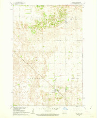
1960 Map of De Lamere
USGS Topo · Published 1962About this map
De Lamere serves as the primary hub on this North Dakota prairie landscape, situated along the Northern Pacific railroad line. The map reveals a highly structured agricultural grid, characterized by numerous Flowing Wells that supported farming across the townships of Hall and Wyndmere. These artesian water sources were critical to the development of the region during the mid-20th century, providing reliable water in an area otherwise dominated by low-lying wetlands and complex topography.
Find a feature on this map
17 named features on this map. Tap any name to fly to it.
Don’t see what you’re looking for? This feature index may not catch every label — zoom into the map to look around manually.
Map Details
Editions of this 1960 De Lamere Map
This is the sole edition of this map. No revisions or reprints were ever made.
Other maps of this area

1907 · Wyndmere
USGS Topo · 1:125,000

1953 · Fargo
USGS Topo · 1:250,000

1956 · Fargo
USGS Topo · 1:250,000

1958 · Cayuga NW
USGS Topo · 1:24,000

1958 · Hamlin
USGS Topo · 1:24,000

1960 · Wyndmere
USGS Topo · 1:24,000

1960 · Wyndmere NW
USGS Topo · 1:24,000

1960 · Venlo
USGS Topo · 1:24,000

1960 · Milnor
USGS Topo · 1:24,000
1961 · McLeod
USGS Topo · 1:24,000
Featured Places
- Hall Township, ND
- Wyndmere Township, ND
- Sandoun Township, ND
- Rosemeade Township, ND
- Freeman Township, ND