
1960 Map of Milnor
USGS Topo · Published 1962About this map
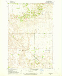
The Milnor townsite anchors the southern edge of this 1960 topographic study, situated at the junction of the Northern Pacific railroad and local rural routes. This southeastern North Dakota landscape is defined by the transitions between the townships of Scoville, Sydnoa, and Milnor, where the Storm Lake National Wildlife Refuge preserves the waters of Storm Lake. The map reveals a high density of local landmarks for genealogists, including School No 21, Lutheran Cem, and Calvary Cem north of town, as well as Lakeside Cem near the wildlife refuge. The terrain is dotted with small depressions and Gravel Pits, characteristic of the glacial drift common across the Ransom and Sargent County line. The presence of the Milnor Airport and a nearby Radio Tower reflect mid-century infrastructure developments in this prairie agricultural hub.
Find a feature on this map
23 named features on this map. Tap any name to fly to it.
Don’t see what you’re looking for? This feature index may not catch every label — zoom into the map to look around manually.
Map Details
Editions of this 1960 Milnor Map
This is the sole edition of this map. No revisions or reprints were ever made.
Other maps of this area

1907 · Wyndmere
USGS Topo · 1:125,000

1953 · Fargo
USGS Topo · 1:250,000

1956 · Fargo
USGS Topo · 1:250,000

1958 · Cayuga NW
USGS Topo · 1:24,000

1958 · Hamlin
USGS Topo · 1:24,000

1960 · Lisbon SE
USGS Topo · 1:24,000

1960 · De Lamere
USGS Topo · 1:24,000

1960 · Lisbon NE
USGS Topo · 1:24,000

1960 · Venlo
USGS Topo · 1:24,000
1961 · McLeod
USGS Topo · 1:24,000