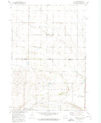
1972 Map of La Mars
USGS Topo · Published 1973About this map
The Sisseton Indian Reservation Boundary cuts across this prairie landscape where the borders of North Dakota and South Dakota meet. Centered on the small settlement of La Mars, the map illustrates a rural township structure defined by section lines, small country schools like School No 1, and local worship centers such as Bethany Ch. The landscape is dominated by the agricultural and conservation geography of the Northern Plains, featuring the expansive Big Slough and the Upper Lake Traverse State Wildlife Management Area. Transport and industry are marked by the Soo Line tracks running through the northern sections and several Gravel Pits scattered across the township of White Rock, while the Hehn Airport provides a glimpse into the era's local aviation infrastructure.
Find a feature on this map
16 named features on this map. Tap any name to fly to it.
Don’t see what you’re looking for? This feature index may not catch every label — zoom into the map to look around manually.
Map Details
Editions of this 1972 La Mars Map
This is the sole edition of this map. No revisions or reprints were ever made.
Other maps of this area

1904 · Wahpeton
USGS Topo · 1:125,000

1915 · White Rock
USGS Topo · 1:62,500

1917 · New Effington
USGS Topo · 1:62,500

1918 · White Rock
USGS Topo · 1:62,500

1953 · Milbank
USGS Topo · 1:250,000

1953 · Fargo
USGS Topo · 1:250,000

1956 · Fargo
USGS Topo · 1:250,000

1958 · Milbank
USGS Topo · 1:250,000

1964 · Hankinson SE
USGS Topo · 1:24,000
1972 · Rosholt
USGS Topo · 1:24,000
Featured Places
- Lake Traverse District, SD
- LaMars Township, ND
- White Rock Hutterite Colony, SD
- Fairmount Township, ND
- La Mars, ND