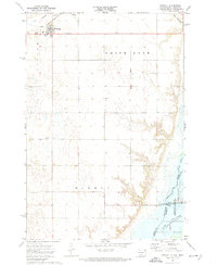
1972 Map of Rosholt
USGS Topo · Published 1974About this map
The town of Rosholt serves as a primary hub in this corner of the Sisseton Indian Reservation, where the prairie landscape is marked by the industrial presence of the Soo Line railroad. The map documents a deeply rooted rural community, evidenced by several country houses of worship and burial grounds, including St Joseph Ch, Trondhjem Ch, and Bethania Cem. To the east, the terrain drops away into the valley of Lake Traverse and Mud Lake, where the Reservation Dam manages water levels along the border between South Dakota and Minnesota. The inclusion of the Hahn Airport and the Townhall reflects the civic and transportation infrastructure supporting the agricultural districts of Victor, White Rock, and Harmon during the early 1970s.
Find a feature on this map
26 named features on this map. Tap any name to fly to it.
Don’t see what you’re looking for? This feature index may not catch every label — zoom into the map to look around manually.
Map Details
Editions of this 1972 Rosholt Map
This is the sole edition of this map. No revisions or reprints were ever made.
Other maps of this area

1915 · White Rock
USGS Topo · 1:62,500

1916 · Peever
USGS Topo · 1:62,500

1916 · Beardsley
USGS Topo · 1:62,500

1917 · New Effington
USGS Topo · 1:62,500

1918 · Peever
USGS Topo · 1:62,500

1918 · White Rock
USGS Topo · 1:62,500

1918 · Beardsley
USGS Topo · 1:62,500

1953 · Milbank
USGS Topo · 1:250,000

1958 · Milbank
USGS Topo · 1:250,000
1971 · Peever NE
USGS Topo · 1:24,000