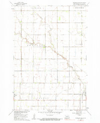
1960 Map of Mooreton West
USGS Topo · Published 1990About this map
Antelope Creek meanders across this prairie landscape in Richland County, its winding course defining the layout of rural sections during the 1960s. The region is strictly organized by the township system, with Nansen, Abercrombie, Antelope, and Ibsen townships meeting in a network of section lines. This survey shows the agricultural character of the era, marked by fine red dashed lines that indicate field and fence boundaries visible from 1950s aerial photography.
Find a feature on this map
12 named features on this map. Tap any name to fly to it.
Don’t see what you’re looking for? This feature index may not catch every label — zoom into the map to look around manually.
Map Details
Editions of this 1960 Mooreton West Map
2 editions found
Other maps of this area

1904 · Wahpeton
USGS Topo · 1:125,000

1907 · Wyndmere
USGS Topo · 1:125,000

1953 · Fargo
USGS Topo · 1:250,000

1956 · Fargo
USGS Topo · 1:250,000

1959 · Wyndmere NE
USGS Topo · 1:24,000

1959 · Mooreton NW
USGS Topo · 1:24,000

1960 · Galchutt
USGS Topo · 1:24,000

1960 · Mooreton West
USGS Topo · 1:24,000

1960 · Wyndmere SE
USGS Topo · 1:24,000

1960 · Mooreton East
USGS Topo · 1:24,000