
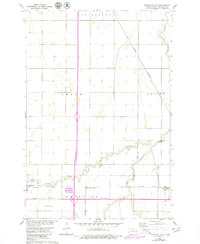
1960 Map of Mooreton East
USGS Topo · Published 1961About this map
Antelope Creek and its meandering South Branch define the agricultural landscape of Richland County in this 1960 planetable survey. The map depicts a region organized by the Public Land Survey System, with the townships of Abercrombie, Ibsen, Dwight, and Mooreton forming a grid of section lines and rural homesteads. At the heart of the local economy is the intersection of rail lines, with the Northern Pacific and Great Northern railroads providing vital connections for small prairie communities. Rural social life is anchored by landmarks like St Paul Ch and Wahpeton School No 5, while the inclusion of Bagg Landing Field suggests the growing importance of aviation in the mid-century Red River Valley. The settlement at Mooreton and the rail-oriented Fairview Junction and Farmington represent the persistent network of grain-handling points and small-town centers typical of North Dakota's eastern plains.
Find a feature on this map
16 named features on this map. Tap any name to fly to it.
Don’t see what you’re looking for? This feature index may not catch every label — zoom into the map to look around manually.
Map Details
Editions of this 1960 Mooreton East Map
2 editions found
Other maps of this area

1904 · Wahpeton
USGS Topo · 1:125,000

1953 · Fargo
USGS Topo · 1:250,000

1956 · Fargo
USGS Topo · 1:250,000

1959 · Mooreton NW
USGS Topo · 1:24,000

1960 · Galchutt
USGS Topo · 1:24,000

1960 · Mooreton West
USGS Topo · 1:24,000

1964 · Fairmount NW
USGS Topo · 1:24,000

1964 · Mantador
USGS Topo · 1:24,000

1964 · Great Bend
USGS Topo · 1:24,000

1964 · Dwight
USGS Topo · 1:24,000