
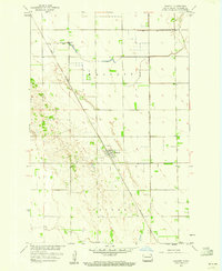
1960 Map of Galchutt
USGS Topo · Published 1961About this map
The Wild Rice River winds in tight oxbows through the flat agricultural heart of Richland County, defining the eastern portion of this 1960 topographic study. The landscape is a grid of section lines and fence lines, supporting small settlements along the competing rail lines that drove early development here. Galchutt and Pitcairn sit along the Great Northern tracks, which bisect the southern half of the map, while Enloe marks a station on the C M St P & P line in the northeast. This era shows the region's reliance on groundwater and local institutions, evidenced by the scattered Flowing Wells and Bethany Ch situated near the river. Beyond the rail-side hamlets like Colfax, the map details hydraulic infrastructure such as the Gaging Sta and the confluence where Antelope Creek joins the main river channel.
Find a feature on this map
14 named features on this map. Tap any name to fly to it.
Don’t see what you’re looking for? This feature index may not catch every label — zoom into the map to look around manually.
Map Details
Editions of this 1960 Galchutt Map
This is the sole edition of this map. No revisions or reprints were ever made.
Other maps of this area

1895 · Fargo
USGS Topo · 1:125,000

1897 · Fargo
USGS Topo · 1:125,000

1904 · Wahpeton
USGS Topo · 1:125,000

1953 · Fargo
USGS Topo · 1:250,000

1956 · Fargo
USGS Topo · 1:250,000

1959 · Mooreton NW
USGS Topo · 1:24,000
1959 · Walcott
USGS Topo · 1:24,000

1959 · Christine
USGS Topo · 1:24,000

1960 · Mooreton West
USGS Topo · 1:24,000

1960 · Mooreton East
USGS Topo · 1:24,000