
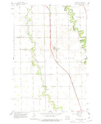
1959 Map of Christine
USGS Topo · Published 1960About this map
The Wild Rice River meanders sharply across the North Dakota plains, creating a complex series of oxbows and loops that define the landscape west of the Red River of the North. This 1959 survey captures a rural landscape heavily influenced by the Chicago Milwaukee St Paul and Pacific railroad, which strings together the small settlements of Lithia, Christine, and Enloe. The map reveals a deeply rooted farming community, marked by a high density of rural institutions such as Pleasant Sch, South Pleasant Ch, and Richland Ch. This era represents a time when local townships like Eagle and Walcott maintained distinct identities before the further consolidation of rural infrastructure. Family researchers will find several well-documented burial grounds, including the Pioneer Cem and Eagle Cem, which anchor the history of these Red River Valley townships.
Find a feature on this map
21 named features on this map. Tap any name to fly to it.
Don’t see what you’re looking for? This feature index may not catch every label — zoom into the map to look around manually.
Map Details
Editions of this 1959 Christine Map
2 editions found
Other maps of this area

1895 · Fargo
USGS Topo · 1:125,000

1897 · Fargo
USGS Topo · 1:125,000

1904 · Wahpeton
USGS Topo · 1:125,000

1953 · Fargo
USGS Topo · 1:250,000

1956 · Fargo
USGS Topo · 1:250,000

1959 · Mooreton NW
USGS Topo · 1:24,000

1959 · Hickson
USGS Topo · 1:24,000
1959 · Walcott
USGS Topo · 1:24,000
1959 · Norman
USGS Topo · 1:24,000

1960 · Galchutt
USGS Topo · 1:24,000