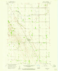
1959 Map of Walcott
USGS Topo · Published 1960About this map
The settlement of Walcott serves as the focal point for this mid-century survey of the Red River Valley in Richland County. This landscape is defined by the rigid geometry of the township and range system, which dictates the layout of the agricultural lands across the Walcott and Colfax boundaries. The Great Northern railroad cuts a sharp diagonal through the terrain, providing the essential transport link for the region's grain-based economy. The map illustrates a transitional phase of development in the Missouri River Basin program, where precise photogrammetric methods from the early 1950s meet on-the-ground planetable surveys from the decade's end. The intricate contour lines reveal the subtle, complex drainage patterns and sand-dune-like formations that vary the otherwise level plains, highlighting the geological heritage of the ancient glacial lake bed.
Find a feature on this map
4 named features on this map. Tap any name to fly to it.
Don’t see what you’re looking for? This feature index may not catch every label — zoom into the map to look around manually.
Map Details
Editions of this 1959 Walcott Map
2 editions found
Other maps of this area

1895 · Fargo
USGS Topo · 1:125,000

1895 · Casselton
USGS Topo · 1:125,000

1897 · Fargo
USGS Topo · 1:125,000

1897 · Casselton
USGS Topo · 1:125,000

1904 · Wahpeton
USGS Topo · 1:125,000

1907 · Wyndmere
USGS Topo · 1:125,000

1953 · Fargo
USGS Topo · 1:250,000

1956 · Fargo
USGS Topo · 1:250,000

1959 · Kindred
USGS Topo · 1:24,000

1959 · Wyndmere NE
USGS Topo · 1:24,000