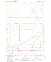
1960 Map of Mooreton East
USGS Topo · Published 1979About this map
The agrarian landscape of Richland County comes into focus here, where the townships of Abercrombie, Ibsen, Dwight, and Mooreton converge. The town of Mooreton serves as a primary hub, situated along the Northern Pacific railroad line. This transportation network was critical for the movement of grain and goods across the Red River Valley, with the Great Northern railroad also traversing the eastern portion of the sheet. The meandering path of Antelope Creek and its tributary, the South Branch Antelope Creek, provide the principal drainage for these expansive fields.
Find a feature on this map
19 named features on this map. Tap any name to fly to it.
Don’t see what you’re looking for? This feature index may not catch every label — zoom into the map to look around manually.
Map Details
Editions of this 1960 Mooreton East Map
2 editions found
Other maps of this area

1904 · Wahpeton
USGS Topo · 1:125,000

1953 · Fargo
USGS Topo · 1:250,000

1956 · Fargo
USGS Topo · 1:250,000

1959 · Mooreton NW
USGS Topo · 1:24,000

1960 · Galchutt
USGS Topo · 1:24,000

1960 · Mooreton West
USGS Topo · 1:24,000

1960 · Mooreton East
USGS Topo · 1:24,000

1964 · Fairmount NW
USGS Topo · 1:24,000

1964 · Mantador
USGS Topo · 1:24,000

1964 · Great Bend
USGS Topo · 1:24,000