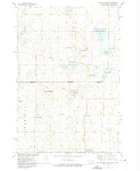
1972 Map of New Effington NW
USGS Topo · Published 1974About this map
Glacial prairie potholes and marshy wetlands define this 1972 landscape along the North Dakota South Dakota border. The map documents the northern reaches of the Sisseton Indian Reservation Boundary, cutting across the townships of Elma, Green Dale, Minnesota, and Lien. This territory is characterized by numerous protected parcels of the National Waterfowl Production Area, interspersed with agricultural field lines and small-scale operations like the Gravel Pit near Big Slough. Genealogists will find notable value in the location of rural burial grounds, including Bohemian Cem and Thompson Cem, which serve as quiet markers of the region's ethnic settlement patterns. The topography is subtle, with the low-lying waters of Indian Slough and other unnamed ponds dominating the drainage patterns across the Richland Co Roberts Co line.
Find a feature on this map
15 named features on this map. Tap any name to fly to it.
Don’t see what you’re looking for? This feature index may not catch every label — zoom into the map to look around manually.
Map Details
Editions of this 1972 New Effington NW Map
This is the sole edition of this map. No revisions or reprints were ever made.
Other maps of this area

1904 · Wahpeton
USGS Topo · 1:125,000

1907 · Wyndmere
USGS Topo · 1:125,000

1917 · New Effington
USGS Topo · 1:62,500

1953 · Milbank
USGS Topo · 1:250,000

1953 · Fargo
USGS Topo · 1:250,000

1956 · Fargo
USGS Topo · 1:250,000

1958 · Milbank
USGS Topo · 1:250,000

1964 · Hankinson
USGS Topo · 1:24,000

1964 · Hankinson SE
USGS Topo · 1:24,000
1964 · Swan Lake
USGS Topo · 1:24,000