1960s Maps of Sargent County, North Dakota
Explore 7 historic maps of Sargent County from the 1960s. These maps offer a rare glimpse into what life looked like during the 1960s — showing old roads, neighborhoods, homes, and landmarks that have changed or disappeared over time.
Whether you're researching your family's past, planning a metal detecting trip, or studying how Sargent County's landscape evolved across the 1960s, these high-resolution maps are a powerful tool for exploring the history of this region.
- Focus on a specific era: All maps on this page are from the 1960s, giving you a focused view of this time period.
- See what’s changed: Compare century-old streets, trails, and buildings to today's modern landscape using overlays and satellite layers.
- Research with precision: Use these maps for genealogy, historical research, land use analysis, or educational projects.
- View, download, or print: Maps are fully viewable online in high resolution, and can be downloaded or printed for your own records.
Start exploring Sargent County's history through authentic maps from the 1960s. This is your window into the past.
Sargent County, ND maps
(7)- 1960 Map of Lisbon SE, 1961 Print
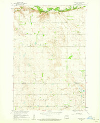 1960 Lisbon SE1961 Print · USGSRansom and Sargent counties are shown here at the start of the 1960s, where the winding valley of the Sheyenne River meets the open prairie. Researchers can trace rural school and church sites like Aliceton Sch and Zion Ch along the Northern Pacific rail corridor.
 - 1960 Map of De Lamere, 1962 Print
 1960 De Lamere1962 Print · USGSThe North Dakota prairie near De Lamere is captured here during the early 1960s as a thriving rail-and-well agricultural hub. Genealogists can locate specific landmarks like the Anderson Cem, School No 1, and the many Flowing Wells that sustained these rural townships.
 - 1960 Map of Milnor, 1962 Print
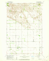
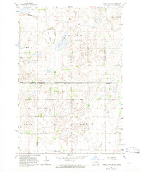
 1960 Milnor1962 Print · USGSSoutheastern North Dakota's prairie landscape is captured here in the early sixties as the town of Milnor sits along the Northern Pacific line. Researchers can locate specific sites like School No 21, Lakeside Cem, and the Storm Lake National Wildlife Refuge.
 - 1962 Map of Hoving, 1964 Print
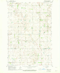
 1962 Hoving1964 Print · USGSSargent County prairie life in the early sixties is captured here as the NORTHERN PACIFIC railway passes through Hoving. Researchers can locate family landmarks such as Zion Cem, Dunbar Cem, and the meandering Crooked Cr.
 - 1962 Map of Lisbon SW, 1964 Print
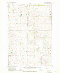
 1962 Lisbon SW1964 Print · USGSRansom and Sargent counties are captured here in the early sixties, showing a landscape of scattered farmsteads and glacial hills. Genealogists can locate family sites near the Lutheran Ch, Cem, or along the banks of Dead Colt Creek.
 - 1962 Map of Gwinner, 1964 Print
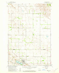
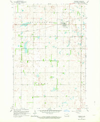 1962 Gwinner1964 Print · USGSSargent County in the early 1960s is captured at a point of industrial and agricultural transition. Genealogists and local historians can trace the early layout of Gwinner, the Northern Pacific rail line, and the location of Gwinner Cem.2 unique versions available
 - 1964 Map of Claire City NW, 1966 Print
 1964 Claire City NW1966 Print · USGSCrossing the North Dakota-South Dakota border in the mid-1960s, this area shows the intersection of the Sisseton Indian Reservation and various county lines. Genealogists can locate family landmarks like Bergen Ch Cem and the Nidaros Ch among the prairie sloughs.
End of results
Showing maps 1-7 of 7
Top cities of Sargent County
- Gwinner historical maps
- Milnor historical maps
- Forman historical maps
- Rutland historical maps
- Cogswell historical maps
- Havana historical maps
See more
Frequently asked questions
- What are the different types of historical maps available for Sargent County?
- What is the oldest map of Sargent County?
- Where can I purchase historical maps of Sargent County for my home or office?
- Where can I download high-res historical maps of Sargent County?
- Are there historical topographic maps available for Sargent County?
- Is there historical aerial imagery available for Sargent County?
- Where are historical maps of Sargent County sourced from?