1980s Maps of Marmarth, North Dakota
Explore 2 historic maps of Marmarth from the 1980s. These maps offer a rare glimpse into what life looked like during the 1980s — showing old roads, neighborhoods, homes, and landmarks that have changed or disappeared over time.
Whether you're researching your family's past, planning a metal detecting trip, or studying how Marmarth's landscape evolved across the 1980s, these high-resolution maps are a powerful tool for exploring the history of this region.
- Focus on a specific era: All maps on this page are from the 1980s, giving you a focused view of this time period.
- See what’s changed: Compare century-old streets, trails, and buildings to today's modern landscape using overlays and satellite layers.
- Research with precision: Use these maps for genealogy, historical research, land use analysis, or educational projects.
- View, download, or print: Maps are fully viewable online in high resolution, and can be downloaded or printed for your own records.
Start exploring Marmarth's history through authentic maps from the 1980s. This is your window into the past.
Marmarth, ND maps
(2)- 1980 Map of Marmarth
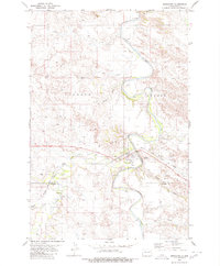 1980 Marmarth1980 Print · USGSThe Little Missouri River valley in the late twentieth century reveals a landscape defined by the Chicago Milwaukee St Paul and Pacific railroad and ranching life. Genealogists and historians can trace the townsite of Marmarth, find the Riverside Cemetery, and locate the Rodeo Ground and Pretty Butte.
 - 1981 Map of Bowman
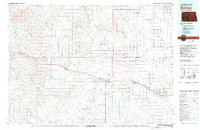 1981 Bowman1981 Print · USGSSouthwestern North Dakota in the early eighties was a landscape of high-plains ranching and rail-centered commerce. Genealogists and historians can trace the rail towns of Bowman, Marmarth, and Amidon while identifying landmarks like White Butte and Talbot Butte.
End of results
Showing maps 1-2 of 2
Top cities near Marmarth
Frequently asked questions
- What are the different types of historical maps available for Marmarth?
- What is the oldest map of Marmarth?
- Where can I purchase historical maps of Marmarth for my home or office?
- Where can I download high-res historical maps of Marmarth?
- Are there historical topographic maps available for Marmarth?
- Is there historical aerial imagery available for Marmarth?
- Where are historical maps of Marmarth sourced from?