1900s (20th Century) Maps of Gaylord, North Dakota
Explore 6 historic maps of Gaylord from the 1900s (20th Century). These maps offer a rare glimpse into what life looked like during the 1900s — showing old roads, neighborhoods, homes, and landmarks that have changed or disappeared over time.
Whether you're researching your family's past, planning a metal detecting trip, or studying how Gaylord's landscape evolved across the 1900s, these high-resolution maps are a powerful tool for exploring the history of this region.
- Focus on a specific era: All maps on this page are from the 1900s, giving you a focused view of this time period.
- See what’s changed: Compare century-old streets, trails, and buildings to today's modern landscape using overlays and satellite layers.
- Research with precision: Use these maps for genealogy, historical research, land use analysis, or educational projects.
- View, download, or print: Maps are fully viewable online in high resolution, and can be downloaded or printed for your own records.
Start exploring Gaylord's history through authentic maps from the 1900s. This is your window into the past.
Gaylord, ND maps
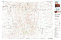
(6)- 1953 Map of Dickinson, 1968 Print
 1953 Dickinson1968 Print · USGSWestern North Dakota in the fifties remains a landscape of rail-linked prairie towns and rugged badlands. Trace the local impact of the Northern Pacific railroad through Dickinson or locate early rural landmarks like Rainy Butte Church and Boys Ranch.2 unique versions available
 - 1957 Map of Dickinson
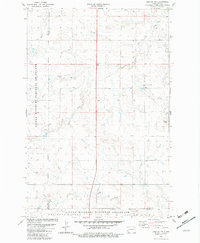
 1957 Dickinson1957 Print · USGSSouthwestern North Dakota in the mid-fifties is a landscape of coal mining and tight-knit rural school districts. Genealogists can trace family footprints through numerous country schools like Fisher School and parish churches like St Stephens.
 - 1961 Map of Daglum, 1963 Print
 1961 Daglum1963 Print · USGSThe western North Dakota plains near the turn of the 1960s reveal a landscape of remote schoolhouses and prairie churches. Researchers can locate vanished rural landmarks like Fisher School, the Daglum Cemetery, and Our Lady of Lourdes Ch.
 - 1980 Map of Belfield, 1981 Print
 1980 Belfield1981 Print · USGSThe North Dakota badlands and the Little Missouri River valley are captured here in the early eighties as energy development and conservation shaped the land. Genealogists and researchers can trace the rail corridor through Medora, Sully Springs, and Beach, or locate early industrial sites like Ridl Mine and the Fryburg Oil Field.
 - 1982 Map of Daglum NW
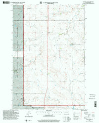
 1982 Daglum NW1982 Print · USGSThe high plains of North Dakota are captured here in the early eighties as the energy industry and rural traditions intersect. Genealogists and historians can trace the foundations of the area through Our Lady of Lourdes Ch, the Rocky Ridge Oil Field, and the settlement at Gaylord.
 - 1997 Map of Daglum NW, 2001 Print
 1997 Daglum NW2001 Print · USGSWestern North Dakota ranching and prairie life are captured in the late nineties as they stood across the Stark and Billings county lines. Genealogists and historians can trace family ties at Our Lady of Lourdes Ch and its Cem, or locate old landmarks like Gaylord and Swenson Ranch.
End of results
Showing maps 1-6 of 6
Top cities near Gaylord
Frequently asked questions
- What are the different types of historical maps available for Gaylord?
- What is the oldest map of Gaylord?
- Where can I purchase historical maps of Gaylord for my home or office?
- Where can I download high-res historical maps of Gaylord?
- Are there historical topographic maps available for Gaylord?
- Is there historical aerial imagery available for Gaylord?
- Where are historical maps of Gaylord sourced from?