1940s Maps of Bremen, North Dakota
Explore 3 historic maps of Bremen from the 1940s. These maps offer a rare glimpse into what life looked like during the 1940s — showing old roads, neighborhoods, homes, and landmarks that have changed or disappeared over time.
Whether you're researching your family's past, planning a metal detecting trip, or studying how Bremen's landscape evolved across the 1940s, these high-resolution maps are a powerful tool for exploring the history of this region.
- Focus on a specific era: All maps on this page are from the 1940s, giving you a focused view of this time period.
- See what’s changed: Compare century-old streets, trails, and buildings to today's modern landscape using overlays and satellite layers.
- Research with precision: Use these maps for genealogy, historical research, land use analysis, or educational projects.
- View, download, or print: Maps are fully viewable online in high resolution, and can be downloaded or printed for your own records.
Start exploring Bremen's history through authentic maps from the 1940s. This is your window into the past.
Bremen, ND maps
(3)- 1948 Map of Cathay
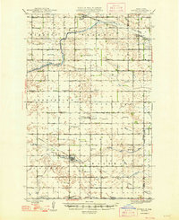 1948 Cathay1948 Print · USGSWells County was a network of rail-towns and prairie parishes in the years following the war. Researchers can trace the family legacies of Cathay and Bremen, identifying rural landmarks like St Josephs Ch, Lake View Cem, and numerous one-room schoolhouses.2 unique versions available
 - 1948 Map of Bremen, 1976 Print
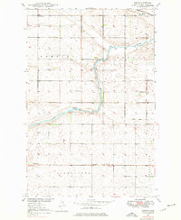 1948 Bremen1976 Print · USGSWells County prairie life is documented here in the late 1940s, centered on the railroad siding and the river valley. Researchers can trace the layout of early rural school districts and find local landmarks like St Josephs Ch and the German Baptist Cem.2 unique versions available
 - 1949 Map of Bremen
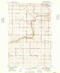 1949 Bremen1949 Print · USGSWells County farming townships and the meandering James River are captured here in the late 1940s. Genealogists and local historians can trace the rural school system and find family landmarks like St Josephs Ch and the German Baptist Cem.
End of results
Showing maps 1-3 of 3
Top cities near Bremen
- Maddock historical maps
- Oberon historical maps
- Munster historical maps
- Cathay historical maps
- Hamberg historical maps
Frequently asked questions
- What are the different types of historical maps available for Bremen?
- What is the oldest map of Bremen?
- Where can I purchase historical maps of Bremen for my home or office?
- Where can I download high-res historical maps of Bremen?
- Are there historical topographic maps available for Bremen?
- Is there historical aerial imagery available for Bremen?
- Where are historical maps of Bremen sourced from?