1990s Maps of Evertonville, Ohio
Explore 2 historic maps of Evertonville from the 1990s. These maps offer a rare glimpse into what life looked like during the 1990s — showing old roads, neighborhoods, homes, and landmarks that have changed or disappeared over time.
Whether you're researching your family's past, planning a metal detecting trip, or studying how Evertonville's landscape evolved across the 1990s, these high-resolution maps are a powerful tool for exploring the history of this region.
- Focus on a specific era: All maps on this page are from the 1990s, giving you a focused view of this time period.
- See what’s changed: Compare century-old streets, trails, and buildings to today's modern landscape using overlays and satellite layers.
- Research with precision: Use these maps for genealogy, historical research, land use analysis, or educational projects.
- View, download, or print: Maps are fully viewable online in high resolution, and can be downloaded or printed for your own records.
Start exploring Evertonville's history through authentic maps from the 1990s. This is your window into the past.
Evertonville, OH maps
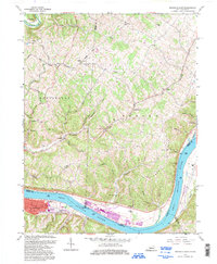
(2)- 1991 Map of Maysville
 1991 Maysville1991 Print · USGSThe Ohio River valley at the turn of the nineties reveals a landscape of river-bend towns and dense forest preserves. Trace local history through landmark sites like Confidence Cemetery, the small-town streets of Ripley, and the river reaches of Manchester Island No 1.
 - 1992 Map of Maysville East, 1997 Print
 1992 Maysville East1997 Print · USGSThe riverfront at Maysville and the surrounding hill country are captured here in the early 1990s as the river economy transitioned. Researchers can locate family landmarks such as Hiett Chapel, Ellis Grove Cem, and the riverside Roadside Park.
End of results
Showing maps 1-2 of 2
Top cities near Evertonville
- Maysville historical maps
- Georgetown historical maps
- West Union historical maps
- Manchester historical maps
- Ripley historical maps
- Aberdeen historical maps
See more
Frequently asked questions
- What are the different types of historical maps available for Evertonville?
- What is the oldest map of Evertonville?
- Where can I purchase historical maps of Evertonville for my home or office?
- Where can I download high-res historical maps of Evertonville?
- Are there historical topographic maps available for Evertonville?
- Is there historical aerial imagery available for Evertonville?
- Where are historical maps of Evertonville sourced from?