1960s Maps of Lima, Ohio
Explore 4 historic maps of Lima from the 1960s. These maps offer a rare glimpse into what life looked like during the 1960s — showing old roads, neighborhoods, homes, and landmarks that have changed or disappeared over time.
Whether you're researching your family's past, planning a metal detecting trip, or studying how Lima's landscape evolved across the 1960s, these high-resolution maps are a powerful tool for exploring the history of this region.
- Focus on a specific era: All maps on this page are from the 1960s, giving you a focused view of this time period.
- See what’s changed: Compare century-old streets, trails, and buildings to today's modern landscape using overlays and satellite layers.
- Research with precision: Use these maps for genealogy, historical research, land use analysis, or educational projects.
- View, download, or print: Maps are fully viewable online in high resolution, and can be downloaded or printed for your own records.
Start exploring Lima's history through authentic maps from the 1960s. This is your window into the past.
Lima, OH maps
(4)- 1960 Map of Cairo, 1961 Print
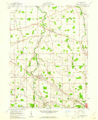
 1960 Cairo1961 Print · USGSAllen County farmland meets the industrial expansion of Lima during the early sixties, showing a landscape defined by heavy rail and institutional grounds. Genealogists can trace family sites like Altstaetter Cem, the crossroads at Cairo, and the Lima State Hospital.4 unique versions available
 - 1960 Map of Elida, 1961 Print
 1960 Elida1961 Print · USGSAllen County at the dawn of the 1960s shows a landscape of river-valley villages and productive farmland on the edge of a growing industrial center. Genealogists and researchers can map the specific locations of Christian Mennonite Sch, Greenlawn Cem, and Gomer.3 unique versions available
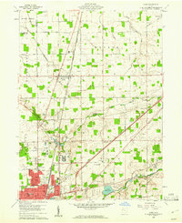
 - 1961 Map of Lima, 1962 Print
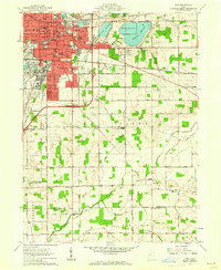 1961 Lima1962 Print · USGSAllen and Auglaize counties were reaching their mid-century peak in this early 1960s survey of the local rail and water infrastructure. Researchers can trace the path of the Old Indian Treaty Boundary or locate family sites at Fletcher Cem and Victory Ch.4 unique versions available
 - 1961 Map of Cridersville, 1963 Print
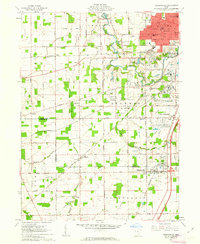 1961 Cridersville1963 Print · USGSSouthern Lima and the surrounding townships are captured in the early sixties during a period of steady industrial and residential growth. Genealogists and researchers can trace family landmarks like Wheeler Cem, rural parishes such as Antioch Ch, and the sprawling Lima Ordnance Modification Center.3 unique versions available
End of results
Showing maps 1-4 of 4
Top cities near Lima
- Wapakoneta historical maps
- Delphos historical maps
- Bluffton historical maps
- Fort Shawnee historical maps
- Spencerville historical maps
- Columbus Grove historical maps
See more
Frequently asked questions
- What are the different types of historical maps available for Lima?
- What is the oldest map of Lima?
- Where can I purchase historical maps of Lima for my home or office?
- Where can I download high-res historical maps of Lima?
- Are there historical topographic maps available for Lima?
- Is there historical aerial imagery available for Lima?
- Where are historical maps of Lima sourced from?