1960s Maps of Austinburg Township, Ohio
Explore 4 historic maps of Austinburg Township from the 1960s. These maps offer a rare glimpse into what life looked like during the 1960s — showing old roads, neighborhoods, homes, and landmarks that have changed or disappeared over time.
Whether you're researching your family's past, planning a metal detecting trip, or studying how Austinburg Township's landscape evolved across the 1960s, these high-resolution maps are a powerful tool for exploring the history of this region.
- Focus on a specific era: All maps on this page are from the 1960s, giving you a focused view of this time period.
- See what’s changed: Compare century-old streets, trails, and buildings to today's modern landscape using overlays and satellite layers.
- Research with precision: Use these maps for genealogy, historical research, land use analysis, or educational projects.
- View, download, or print: Maps are fully viewable online in high resolution, and can be downloaded or printed for your own records.
Start exploring Austinburg Township's history through authentic maps from the 1960s. This is your window into the past.
Austinburg Township, OH maps
(4)- 1960 Map of Ashtabula South, 1961 Print
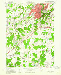 1960 Ashtabula South1961 Print · USGSAshtabula and its southern outskirts are captured here during the early sixties, showing the city's growth alongside its deep river valleys. Genealogists and local historians can trace family locations near the Grand River Academy High Sch, the Covered Bridge, and various landmarks like the Ridgeview Burial Park.3 unique versions available
 - 1960 Map of Geneva, 1961 Print
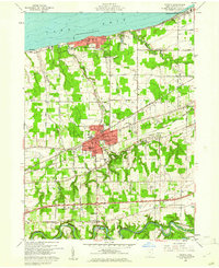 1960 Geneva1961 Print · USGSThe Lake Erie shoreline and the city of Geneva are captured here in the early sixties, showing a landscape defined by resort growth and heavy rail. Trace family heritage at Evergreen Cem or follow the Grand River past Mechanicsville.5 unique versions available
 - 1960 Map of Jefferson, 1962 Print
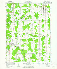 1960 Jefferson1962 Print · USGSJefferson and the surrounding Ashtabula County countryside are captured here in the early sixties, showing a landscape defined by its Western Reserve roots. Trace the old rail lines of the Pennsylvania or find family landmarks like Oakdale Cem and Lenox Center.3 unique versions available
 - 1962 Map of Cleveland
 1962 Cleveland1962 Print · USGSNortheast Ohio and the Pennsylvania borderlands appear here during the industrial peak of the early sixties. Genealogists and historians can trace the expansive rail lines of the Nickel Plate Road and the growth of suburbs from Parma to Lyndhurst.
End of results
Showing maps 1-4 of 4
Top cities near Austinburg Township
- Ashtabula historical maps
- Saybrook historical maps
- North Madison historical maps
- Geneva historical maps
- Edgewood historical maps
- Madison historical maps
See more
Top neighborhoods of Austinburg Township
- Eagleville historical maps
- Cold Springs historical maps
- Mechanicsville historical maps
- Austinburg historical maps
Frequently asked questions
- What are the different types of historical maps available for Austinburg Township?
- What is the oldest map of Austinburg Township?
- Where can I purchase historical maps of Austinburg Township for my home or office?
- Where can I download high-res historical maps of Austinburg Township?
- Are there historical topographic maps available for Austinburg Township?
- Is there historical aerial imagery available for Austinburg Township?
- Where are historical maps of Austinburg Township sourced from?