1990s Maps of Morgan Township, Ohio
Explore 3 historic maps of Morgan Township from the 1990s. These maps offer a rare glimpse into what life looked like during the 1990s — showing old roads, neighborhoods, homes, and landmarks that have changed or disappeared over time.
Whether you're researching your family's past, planning a metal detecting trip, or studying how Morgan Township's landscape evolved across the 1990s, these high-resolution maps are a powerful tool for exploring the history of this region.
- Focus on a specific era: All maps on this page are from the 1990s, giving you a focused view of this time period.
- See what’s changed: Compare century-old streets, trails, and buildings to today's modern landscape using overlays and satellite layers.
- Research with precision: Use these maps for genealogy, historical research, land use analysis, or educational projects.
- View, download, or print: Maps are fully viewable online in high resolution, and can be downloaded or printed for your own records.
Start exploring Morgan Township's history through authentic maps from the 1990s. This is your window into the past.
Morgan Township, OH maps
(3)- 1994 Map of Orwell, 1997 Print
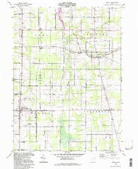 1994 Orwell1997 Print · USGSAshtabula County and the Trumbull line in the mid-1990s show a landscape shaped by the Connecticut Western Reserve's original grids. Genealogists can locate family plots at South Orwell Cem or trace the old rail stops at Rome Station and New Lyme Station.
 - 1994 Map of Jefferson, 1997 Print
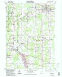 1994 Jefferson1997 Print · USGSAshtabula County's rural landscape is captured here in the mid-nineties, from the village of Jefferson to the banks of the Grand State Wild and Scenic River. Genealogists can locate family sites near Oakdale Cem and the crossroads of Lenox Center.
 - 1994 Map of East Trumbull, 1997 Print
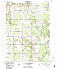 1994 East Trumbull1997 Print · USGSThe Grand River valley in Ashtabula County appears here in the mid-nineties, showing a landscape of state preserves and family farms. Local historians can trace family-named sites like South River Road Cem, Footville, and the South Harpersfield Ch.
End of results
Showing maps 1-3 of 3
Top cities near Morgan Township
- Ashtabula historical maps
- Saybrook historical maps
- North Madison historical maps
- Geneva historical maps
- Edgewood historical maps
- Madison historical maps
See more
Top neighborhoods of Morgan Township
Frequently asked questions
- What are the different types of historical maps available for Morgan Township?
- What is the oldest map of Morgan Township?
- Where can I purchase historical maps of Morgan Township for my home or office?
- Where can I download high-res historical maps of Morgan Township?
- Are there historical topographic maps available for Morgan Township?
- Is there historical aerial imagery available for Morgan Township?
- Where are historical maps of Morgan Township sourced from?