1960s Maps of Barnesville, Ohio
Explore 4 historic maps of Barnesville from the 1960s. These maps offer a rare glimpse into what life looked like during the 1960s — showing old roads, neighborhoods, homes, and landmarks that have changed or disappeared over time.
Whether you're researching your family's past, planning a metal detecting trip, or studying how Barnesville's landscape evolved across the 1960s, these high-resolution maps are a powerful tool for exploring the history of this region.
- Focus on a specific era: All maps on this page are from the 1960s, giving you a focused view of this time period.
- See what’s changed: Compare century-old streets, trails, and buildings to today's modern landscape using overlays and satellite layers.
- Research with precision: Use these maps for genealogy, historical research, land use analysis, or educational projects.
- View, download, or print: Maps are fully viewable online in high resolution, and can be downloaded or printed for your own records.
Start exploring Barnesville's history through authentic maps from the 1960s. This is your window into the past.
Barnesville, OH maps
(4)- 1961 Map of Clarksburg
 1961 Clarksburg1961 Print · USGSThe mid-century industrial and river landscapes of West Virginia and Ohio are detailed here, centered on the Ohio River. Researchers can trace the Baltimore and Ohio rail lines connecting towns like Parkersburg, Clarksburg, and Monongah.
 - 1961 Map of Fairview, 1962 Print
 1961 Fairview1962 Print · USGSThe Guernsey and Belmont county border area was undergoing significant change in the 1960s as highway expansion met traditional coal mining. Researchers can trace family history through Salem Ch and Gibson Cem or locate industrial sites like the Strip Mines and Bradfield Airport.3 unique versions available
 - 1961 Map of Barnesville, 1963 Print
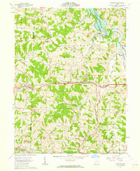
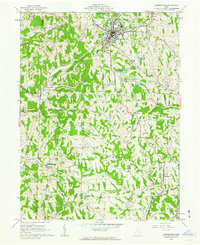 1961 Barnesville1963 Print · USGSThe hilltop town of Barnesville thrived in the early sixties as a center for industry and education in eastern Ohio. Researchers can trace family history through the Old Quaker Cemetery, find the Friends School, or locate rural outposts like Baileys Mills and Somerton.3 unique versions available
 - 1962 Map of Canton
 1962 Canton1962 Print · USGSThe industrial heartland of Eastern Ohio and Western Pennsylvania thrives in the early sixties as steel mills and rail lines dominate the river valleys. Genealogists and historians can trace local landmarks like McKinley National Memorial, Malone College, and industrial sites such as Republic Steel Corp.2 unique versions available
End of results
Showing maps 1-4 of 4
Top cities near Barnesville
- Woodsfield historical maps
- Bethesda historical maps
- Malaga historical maps
- Flushing historical maps
- Londonderry historical maps
- Quaker City historical maps
See more
Top neighborhoods of Barnesville
Frequently asked questions
- What are the different types of historical maps available for Barnesville?
- What is the oldest map of Barnesville?
- Where can I purchase historical maps of Barnesville for my home or office?
- Where can I download high-res historical maps of Barnesville?
- Are there historical topographic maps available for Barnesville?
- Is there historical aerial imagery available for Barnesville?
- Where are historical maps of Barnesville sourced from?