1910s Maps of Carroll County, Ohio
Explore 4 historic maps of Carroll County from the 1910s. These maps offer a rare glimpse into what life looked like during the 1910s — showing old roads, neighborhoods, homes, and landmarks that have changed or disappeared over time.
Whether you're researching your family's past, planning a metal detecting trip, or studying how Carroll County's landscape evolved across the 1910s, these high-resolution maps are a powerful tool for exploring the history of this region.
- Focus on a specific era: All maps on this page are from the 1910s, giving you a focused view of this time period.
- See what’s changed: Compare century-old streets, trails, and buildings to today's modern landscape using overlays and satellite layers.
- Research with precision: Use these maps for genealogy, historical research, land use analysis, or educational projects.
- View, download, or print: Maps are fully viewable online in high resolution, and can be downloaded or printed for your own records.
Start exploring Carroll County's history through authentic maps from the 1910s. This is your window into the past.
Carroll County, OH maps
(4)- 1910 Map of Carrollton, 1957 Print
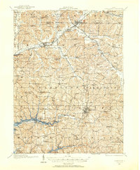 1910 Carrollton1957 Print · USGSCarroll County and parts of Stark and Columbiana counties are documented here during an era of robust rail expansion and rural development. Genealogists can trace family footprints across dozens of local landmarks like Phalana Hall School, Macedonia Church, and the County Infirmary.
 - 1911 Map of Uhrichsville, 1937 Print
 1911 Uhrichsville1937 Print · USGSTuscarawas County's industrial river valleys and canal routes are shown here at their height before the mid-century decline of rail. Researchers can trace the path of the Ohio and Erie Canal and locate family-named landmarks like Beidler P O, Wesley Church, and Gnadenhutten.
 - 1912 Map of Dover, 1939 Print
 1912 Dover1939 Print · USGSTuscarawas and Stark Counties are shown in the early twentieth century as coal and rail corridors shaped the valley floors. Researchers can locate unique landmarks like the Octagonal School, the historic Zoar community, and the path of the Ohio Treaty Line.2 unique versions available
 - 1912 Map of Carrollton, 1943 Print
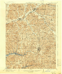 1912 Carrollton1943 Print · USGSThe hills of Carroll County are shown at a peak of rural development in the early 20th century, before major modern changes. Genealogists can trace family roots through numerous local landmarks like Mud School, the County Infirmary, and Harlem Springs.
End of results
Showing maps 1-4 of 4
Top cities of Carroll County
- Carrollton historical maps
- Sherrodsville historical maps
- Dellroy historical maps
- Leesville historical maps
Frequently asked questions
- What are the different types of historical maps available for Carroll County?
- What is the oldest map of Carroll County?
- Where can I purchase historical maps of Carroll County for my home or office?
- Where can I download high-res historical maps of Carroll County?
- Are there historical topographic maps available for Carroll County?
- Is there historical aerial imagery available for Carroll County?
- Where are historical maps of Carroll County sourced from?