1990s Maps of Center Township, Ohio
Explore 2 historic maps of Center Township from the 1990s. These maps offer a rare glimpse into what life looked like during the 1990s — showing old roads, neighborhoods, homes, and landmarks that have changed or disappeared over time.
Whether you're researching your family's past, planning a metal detecting trip, or studying how Center Township's landscape evolved across the 1990s, these high-resolution maps are a powerful tool for exploring the history of this region.
- Focus on a specific era: All maps on this page are from the 1990s, giving you a focused view of this time period.
- See what’s changed: Compare century-old streets, trails, and buildings to today's modern landscape using overlays and satellite layers.
- Research with precision: Use these maps for genealogy, historical research, land use analysis, or educational projects.
- View, download, or print: Maps are fully viewable online in high resolution, and can be downloaded or printed for your own records.
Start exploring Center Township's history through authentic maps from the 1990s. This is your window into the past.
Center Township, OH maps
(2)- 1994 Map of Carrollton, 1998 Print
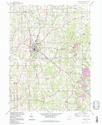 1994 Carrollton1998 Print · USGSCarrollton and its surrounding townships are shown here in the 1990s, caught between their agricultural roots and a significant coal mining history. Genealogists can trace family names and local sites from Harlem Springs to Wherrys Crossroads, including Mt Olivet Ch and the Wherry Cem.
 - 1994 Map of Dellroy, 1998 Print
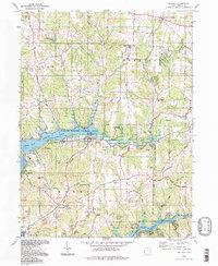 1994 Dellroy1998 Print · USGSThe rolling hills of Carroll County are defined by mid-century conservation and coal mining. Researchers can trace family history at Baxter Ridge Cem or locate former transit lines along the Old Railroad Grade near Dellroy.
End of results
Showing maps 1-2 of 2
Top cities near Center Township
- Canton historical maps
- Paris historical maps
- Minerva historical maps
- Carrollton historical maps
- East Canton historical maps
- Augusta historical maps
See more
Top neighborhoods of Center Township
Frequently asked questions
- What are the different types of historical maps available for Center Township?
- What is the oldest map of Center Township?
- Where can I purchase historical maps of Center Township for my home or office?
- Where can I download high-res historical maps of Center Township?
- Are there historical topographic maps available for Center Township?
- Is there historical aerial imagery available for Center Township?
- Where are historical maps of Center Township sourced from?