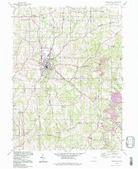
1994 Map of Carrollton
USGS Topo · Published 1998About this map
Carrollton serves as the central hub of this eastern Ohio landscape, where the local economy transition from the civic center to industrial extraction at the county's edge. The town is marked by local landmarks like the Fairgrounds, Municipal Park, and Waterworks Park, while the surrounding countryside is defined by the legacy of resource removal. To the east and southeast, extensive Strip Mines and numerous Mine symbols reveal the region's relationship with its coal deposits, particularly near Harlem Springs.
Find a feature on this map
55 named features on this map. Tap any name to fly to it.
Don’t see what you’re looking for? This feature index may not catch every label — zoom into the map to look around manually.
Map Details
Editions of this 1994 Carrollton Map
This is the sole edition of this map. No revisions or reprints were ever made.
Other maps of this area

1901 · Cadiz
USGS Topo · 1:62,500

1902 · Scio
USGS Topo · 1:62,500

1903 · Cadiz
USGS Topo · 1:62,500

1904 · Scio
USGS Topo · 1:62,500

1905 · Salineville
USGS Topo · 1:62,500

1910 · Carrollton
USGS Topo · 1:62,500

1912 · Carrollton
USGS Topo · 1:62,500

1951 · Canton
USGS Topo · 1:250,000

1953 · Canton
USGS Topo · 1:250,000

1957 · Canton
USGS Topo · 1:250,000