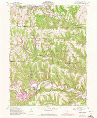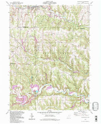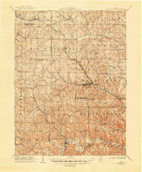
1905 Map of Salineville
USGS Topo · Published 1948About this map
Salineville serves as the industrial and transit hub of this early 20th-century landscape where Columbiana, Carroll, and Jefferson counties meet. The convergence of the Cleveland and Pittsburg and New York Central rail lines highlights the importance of transportation to this region, connecting coal and clay resources to larger markets. To the south, the village of Bergholz sits along the winding course of Yellow Creek, surrounded by a network of smaller farming settlements like Scroggsfield and Mechanicstown.
Find a feature on this map
63 named features on this map. Tap any name to fly to it.
Don’t see what you’re looking for? This feature index may not catch every label — zoom into the map to look around manually.
Map Details
Editions of this 1905 Salineville Map
This is the sole edition of this map. No revisions or reprints were ever made.
Historical Maps of Salineville Through Time
8 maps found