1980s Maps of Franklin Township, Ohio
Explore 3 historic maps of Franklin Township from the 1980s. These maps offer a rare glimpse into what life looked like during the 1980s — showing old roads, neighborhoods, homes, and landmarks that have changed or disappeared over time.
Whether you're researching your family's past, planning a metal detecting trip, or studying how Franklin Township's landscape evolved across the 1980s, these high-resolution maps are a powerful tool for exploring the history of this region.
- Focus on a specific era: All maps on this page are from the 1980s, giving you a focused view of this time period.
- See what’s changed: Compare century-old streets, trails, and buildings to today's modern landscape using overlays and satellite layers.
- Research with precision: Use these maps for genealogy, historical research, land use analysis, or educational projects.
- View, download, or print: Maps are fully viewable online in high resolution, and can be downloaded or printed for your own records.
Start exploring Franklin Township's history through authentic maps from the 1980s. This is your window into the past.
Franklin Township, OH maps
(3)- 1981 Map of Laurel, 1982 Print
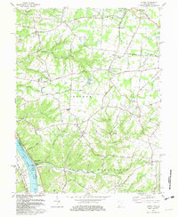 1981 Laurel1982 Print · USGSClermont County's riverfront and rural interior are captured here in the early 1980s, documenting a landscape of small hamlets and family-named landmarks. Genealogists can trace sites like Monroe Cem, Franklin Chapel, and the historic river town of Point Pleasant.2 unique versions available
 - 1981 Map of Moscow, 1982 Print
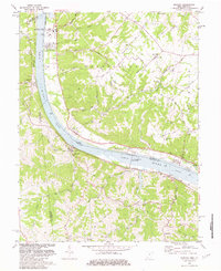 1981 Moscow1982 Print · USGSThe Ohio River valley near Moscow, Ohio, shows a landscape of heavy river infrastructure and ridge-top farming in the early eighties. Researchers can trace rural lineages through family-named landmarks like Fruit Ridge, McKendree Cem, and the old Flat Rock Ch.2 unique versions available
 - 1986 Map of Falmouth
 1986 Falmouth1986 Print · USGSNorthern Kentucky and the Ohio River valley are shown here in the mid-1980s, highlighting the region's complex river-and-rail geography. Genealogists and researchers can trace the roads connecting Big Bone Lick, Zion Church, and river towns like Falmouth and Augusta.2 unique versions available
End of results
Showing maps 1-3 of 3
Top cities near Franklin Township
- Amelia historical maps
- Georgetown historical maps
- Mount Orab historical maps
- Bethel historical maps
- New Richmond historical maps
- Williamsburg historical maps
See more
Top neighborhoods of Franklin Township
- Mount Olive historical maps
- Stringtown historical maps
- Utopia historical maps
- Cedron historical maps
- Rural historical maps
- Felicity historical maps
See more
Frequently asked questions
- What are the different types of historical maps available for Franklin Township?
- What is the oldest map of Franklin Township?
- Where can I purchase historical maps of Franklin Township for my home or office?
- Where can I download high-res historical maps of Franklin Township?
- Are there historical topographic maps available for Franklin Township?
- Is there historical aerial imagery available for Franklin Township?
- Where are historical maps of Franklin Township sourced from?