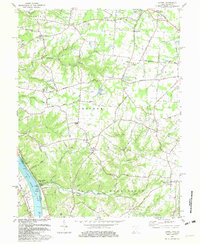
1981 Map of Laurel
USGS Topo · Published 1982About this map
Point Pleasant sits as a riverfront anchor on the northern bank of the Ohio River, serving as a focal point for this 1980s landscape in Clermont County. The map details a transition from the industrial and transport corridor of the Chesapeake and Ohio Railway to the rural townships of Monroe, Washington, and Tate. This area is characterized by a dense network of small family and community landmarks, such as the Monroe Cem and Laurel Cem, and numerous country churches including Tabernacle Ch and Franklin Chapel.
Find a feature on this map
68 named features on this map. Tap any name to fly to it.
Don’t see what you’re looking for? This feature index may not catch every label — zoom into the map to look around manually.
Map Details
Editions of this 1981 Laurel Map
2 editions found
Other maps of this area

1898 · East Cincinnati
USGS Topo · 1:62,500

1914 · East Cincinnati
USGS Topo · 1:62,500

1914 · Batavia
USGS Topo · 1:48,000

1916 · Batavia
USGS Topo · 1:62,500

1929 · Alexandria
USGS Topo · 1:48,000

1931 · Felicity
USGS Topo · 1:62,500

1936 · Alexandria
USGS Topo · 1:62,500

1953 · Laurel
USGS Topo · 1:24,000

1953 · Withamsville
USGS Topo · 1:24,000

1953 · Bethel
USGS Topo · 1:24,000