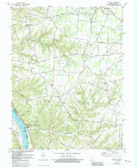
1981 Map of Laurel
USGS Topo · Published 1992About this map
Point Pleasant and the high bluffs overlooking the Ohio River anchor this 1981 survey of Clermont County. The landscape is defined by the deep incisions of Twelvemile Creek, Big Indian Creek, and Little Indian Creek as they drain toward the river. Historically significant for being the birthplace of Ulysses S. Grant, Point Pleasant sits near the confluence of Big Indian Creek, while further inland, the topography shifts into a plateau of agricultural fields and small settlements like Laurel and Nicholsville. Traces of earlier transportation networks remain visible, specifically the Old Railroad Grade north of Hulington. Community life is marked by numerous country churches and burial grounds, including Spring Grove Chapel, Franklin Chapel, and the Laurel Cem, which serve the rural population scattered across Monroe and Washington townships.
Find a feature on this map
76 named features on this map. Tap any name to fly to it.
Don’t see what you’re looking for? This feature index may not catch every label — zoom into the map to look around manually.
Map Details
Editions of this 1981 Laurel Map
2 editions found
Other maps of this area

1898 · East Cincinnati
USGS Topo · 1:62,500

1914 · East Cincinnati
USGS Topo · 1:62,500

1914 · Batavia
USGS Topo · 1:48,000

1916 · Batavia
USGS Topo · 1:62,500

1929 · Alexandria
USGS Topo · 1:48,000

1931 · Felicity
USGS Topo · 1:62,500

1936 · Alexandria
USGS Topo · 1:62,500

1953 · Laurel
USGS Topo · 1:24,000

1953 · Withamsville
USGS Topo · 1:24,000

1953 · Bethel
USGS Topo · 1:24,000