
1914 Map of Batavia
USGS Topo · Published 1914About this map
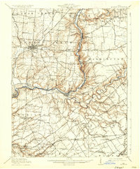
Batavia and Williamsburg anchor this 1914 study of Clermont County, where the East Fork Little Miami River carves a deep valley through the local topography. The landscape is defined by an intricate network of early 20th-century transportation, including the Norfolk and Western Railway and several interurban lines like the Cincinnati and Columbus Electric Railway. Outside the primary towns, the map reveals a high density of rural social centers, from the uniquely named School Not Modest and Spread Eagle School to the Mt Zion Church. Genealogists can trace family holdings and neighborhood hubs like Possum Hollow, Afton Sta, and Olive Branch, which illustrate the transition from a traditional river-and-rail economy to the emerging electric traction era.
Find a feature on this map
94 named features on this map. Tap any name to fly to it.
Don’t see what you’re looking for? This feature index may not catch every label — zoom into the map to look around manually.
Map Details
Editions of this 1914 Batavia Map
This is the sole edition of this map. No revisions or reprints were ever made.
Other maps of this area

1898 · East Cincinnati
USGS Topo · 1:62,500

1904 · Mason
USGS Topo · 1:62,500

1906 · Mason
USGS Topo · 1:62,500

1907 · Blanchester
USGS Topo · 1:62,500

1914 · East Cincinnati
USGS Topo · 1:62,500

1914 · Morrow
USGS Topo · 1:62,500

1916 · Batavia
USGS Topo · 1:62,500
1916 · Morrow
USGS Topo · 1:62,500

1917 · Sardinia
USGS Topo · 1:62,500

1928 · Higginsport
USGS Topo · 1:48,000
Featured Places
- Stonelick Township, OH
- Amelia, Batavia Township
- Mulberry, Miami Township
- Williamsburg, Williamsburg Township
- Batavia, Batavia Township