1914 Map of Morrow
USGS Topo · Published 1963About this map
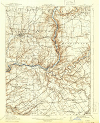
The Little Miami River carves a winding path through this corner of Warren County, where a dense network of early 20th-century railroads supported the region's agricultural and industrial growth. The P. C. C. and St. L. RR and several electric lines, including the C. L. and N. Electric RR, connect major hubs like Lebanon and Morrow. The topography is defined by significant landmarks such as the earthworks of Fort Ancient and social infrastructure like the County Infirmary and Childrens Home.
Find a feature on this map
125 named features on this map. Tap any name to fly to it.
Don’t see what you’re looking for? This feature index may not catch every label — zoom into the map to look around manually.
Map Details
Editions of this 1914 Morrow Map
This is the sole edition of this map. No revisions or reprints were ever made.