1960s Maps of Clinton County, Ohio
Explore 17 historic maps of Clinton County from the 1960s. These maps offer a rare glimpse into what life looked like during the 1960s — showing old roads, neighborhoods, homes, and landmarks that have changed or disappeared over time.
Whether you're researching your family's past, planning a metal detecting trip, or studying how Clinton County's landscape evolved across the 1960s, these high-resolution maps are a powerful tool for exploring the history of this region.
- Focus on a specific era: All maps on this page are from the 1960s, giving you a focused view of this time period.
- See what’s changed: Compare century-old streets, trails, and buildings to today's modern landscape using overlays and satellite layers.
- Research with precision: Use these maps for genealogy, historical research, land use analysis, or educational projects.
- View, download, or print: Maps are fully viewable online in high resolution, and can be downloaded or printed for your own records.
Start exploring Clinton County's history through authentic maps from the 1960s. This is your window into the past.
Clinton County, OH maps
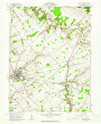
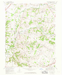
(17)- 1960 Map of Lynchburg, 1962 Print
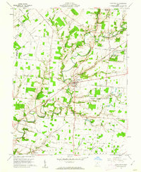
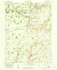 1960 Lynchburg1962 Print · USGSHighland and Clinton counties are shown at the start of the 1960s, documenting a landscape of rural schoolhouses and family cemeteries within the Virginia Military District. Researchers can trace the path of the Baltimore and Ohio railroad through Lynchburg or locate rural landmarks like Salem Sch and Stroup Cem.3 unique versions available
 - 1960 Map of Martinsville, 1962 Print
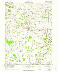 1960 Martinsville1962 Print · USGSClinton and Highland counties are shown in the early 1960s as a thriving agricultural landscape defined by the Baltimore and Ohio RR. Researchers can trace old family roots through sites like Klocks Crossing, IOOF Cem, and the rural Glady Ch.
 - 1960 Map of Leesburg, 1962 Print
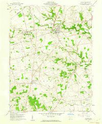 1960 Leesburg1962 Print · USGSHighland County farmland in the early sixties is anchored by the rail crossing at Leesburg and the rural crossroads of Samantha. Genealogists can locate numerous burial sites and community landmarks including Antioch Cem, Township Sch, and Hardin Creek Ch.3 unique versions available
 - 1960 Map of Clarksville, 1962 Print
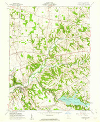 1960 Clarksville1962 Print · USGSThe Clinton and Warren county line runs through this early 1960s landscape as the newly established Cowan State Park takes shape. Genealogists can trace local roots at Jonahs Run Ch, Sewell Cem, and the village of Clarksville.3 unique versions available
 - 1960 Map of Fayetteville, 1962 Print
 1960 Fayetteville1962 Print · USGSBrown County in the early sixties remains a landscape of traditional farming communities and religious institutions. Genealogists can trace family names at Engle Cem or Dunham Cem and explore the grounds of the Ursuline School for Girls.2 unique versions available
 - 1960 Map of New Vienna, 1962 Print
 1960 New Vienna1962 Print · USGSThe borderlands of Clinton and Highland Counties come into focus in the early sixties, centered on the railroad hub of New Vienna. Genealogists can trace family names and rural sites like the Gist Settlement, Odd Fellows Cem, and Fairview Ch.2 unique versions available
 - 1961 Map of Columbus
 1961 Columbus1961 Print · USGSCentral and Southern Ohio are captured here in the early sixties, as the region's industrial rail hubs and military bases reached their peak. Genealogists and historians can trace the transition from urban Columbus to rural townships along the Scioto River, locating Lockbourne USAF and old junctions like Washington Court House.
 - 1961 Map of Memphis, 1962 Print
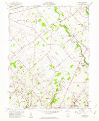 1961 Memphis1962 Print · USGSCentral Ohio’s agricultural landscape is captured here in the early 1960s, showing the rural communities of Sabina and Memphis. Genealogists can trace family roots at Evans Cem, Jeff Cem, and Anders Cem or locate the old Walnut Hill Sch.2 unique versions available
 - 1961 Map of Wilmington, 1962 Print
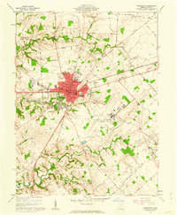 1961 Wilmington1962 Print · USGSWilmington and the surrounding Clinton County townships are captured here in the early sixties as a center of higher education and military aviation. Researchers can trace historic institutions like Wilmington College and the Clinton County Air Force Base, or locate family sites at Dover Cem and Starbucktown.4 unique versions available
 - 1961 Map of Blanchester, 1962 Print
 1961 Blanchester1962 Print · USGSClinton County’s railroad heritage is on full display during the early sixties, centered on the bustling junction at Blanchester. Genealogists and local historians can trace family farmsteads along Nauvoo Road and locate historic burial sites like Rehoboth Cem or the IOOF Cem.4 unique versions available
 - 1961 Map of Sabina, 1962 Print
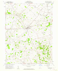
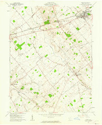 1961 Sabina1962 Print · USGSClinton County farming and rail life are preserved here during the early sixties, centered on the crossing tracks in Sabina. Researchers can trace old family lines through rural landmarks like Richland Ch, the Simon Kenton Sch, and Spurgeon Cem.2 unique versions available
 - 1961 Map of Milledgeville, 1963 Print
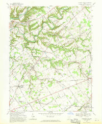
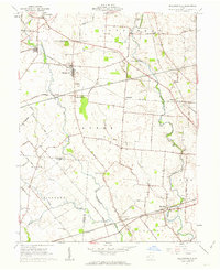 1961 Milledgeville1963 Print · USGSFayette and Clinton Counties are captured at a peak of rural rail activity in the early sixties. Genealogists can locate family burial sites at Asbury Chapel Cem or Hines Cem and trace the paths of the Baltimore and Ohio RR.3 unique versions available
 - 1961 Map of Bowersville, 1963 Print
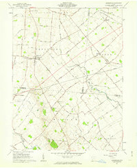 1961 Bowersville1963 Print · USGSThe rural landscape of Greene and Clinton counties is documented here in the early sixties, showing a region defined by its small farming settlements and family cemeteries. Genealogists can trace local roots at Hussey Cem and Grassy Run Cem or locate old community centers like Bowersville and Bloomington.2 unique versions available
 - 1962 Map of Columbus
 1962 Columbus1962 Print · USGSCentral Ohio during the early sixties reveals a transition from the industrial corridors of Columbus to the forested ridges of the south. Genealogists and historians can trace the rail networks of the Baltimore & Ohio RR and find local landmarks like Washington Court House and Camp Sherman Military Reservation.
 - 1967 Map of Columbus, 1969 Print
 1967 Columbus1969 Print · USGSCentral Ohio during the late sixties serves as a vital corridor of rail and aviation, from the industrial streets of Springfield to the hangar lines of Lockbourne Air Force Base. Genealogists and researchers can trace the growth of towns like Circleville and London or locate rural landmarks such as St Paul church and the London Correctional Institution.2 unique versions available
 - 1968 Map of New Burlington, 1969 Print
 1968 New Burlington1969 Print · USGSSouthwestern Ohio at the close of the sixties reveals a landscape of quiet rural villages and river crossings. Researchers can locate the Covered Bridge at New Burlington, the Indian Mound in Massie, and family sites near Richland Church.4 unique versions available
 - 1968 Map of Pleasant Plain, 1970 Print
 1968 Pleasant Plain1970 Print · USGSWarren County at the end of the sixties reveals a landscape of established rail lines and winding river valleys. Genealogists and local historians can trace family ties through numerous rural burial sites like West Mary Cemetery and Spurling Cemetery or locate the historic Harlan Butlerville School.
End of results
Showing maps 1-17 of 17
Top cities of Clinton County
Frequently asked questions
- What are the different types of historical maps available for Clinton County?
- What is the oldest map of Clinton County?
- Where can I purchase historical maps of Clinton County for my home or office?
- Where can I download high-res historical maps of Clinton County?
- Are there historical topographic maps available for Clinton County?
- Is there historical aerial imagery available for Clinton County?
- Where are historical maps of Clinton County sourced from?