1960s Maps of Leetonia, Ohio
Explore 5 historic maps of Leetonia from the 1960s. These maps offer a rare glimpse into what life looked like during the 1960s — showing old roads, neighborhoods, homes, and landmarks that have changed or disappeared over time.
Whether you're researching your family's past, planning a metal detecting trip, or studying how Leetonia's landscape evolved across the 1960s, these high-resolution maps are a powerful tool for exploring the history of this region.
- Focus on a specific era: All maps on this page are from the 1960s, giving you a focused view of this time period.
- See what’s changed: Compare century-old streets, trails, and buildings to today's modern landscape using overlays and satellite layers.
- Research with precision: Use these maps for genealogy, historical research, land use analysis, or educational projects.
- View, download, or print: Maps are fully viewable online in high resolution, and can be downloaded or printed for your own records.
Start exploring Leetonia's history through authentic maps from the 1960s. This is your window into the past.
Leetonia, OH maps
(5)- 1960 Map of Elkton
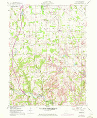 1960 Elkton1960 Print · USGSColumbiana County at the start of the 1960s shows a landscape defined by coal mining and heavy rail. Genealogists can locate several rural burying grounds like Church Hill Cem and Zepperick Cem alongside the tracks of the Penn Central and Erie-Lackawanna railroads.2 unique versions available
 - 1960 Map of Lisbon, 1962 Print
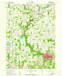 1960 Lisbon1962 Print · USGSLisbon and the surrounding Columbiana County countryside are captured here in the early sixties as industrial mining and rail networks intersected with local rural life. Genealogists and historians can trace family roots through the Phillips Cem, St Jacobs Ch, and schools like Lincoln Sch.4 unique versions available
 - 1962 Map of Canton
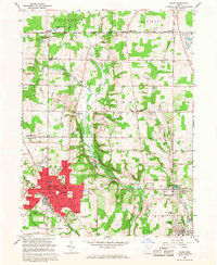
 1962 Canton1962 Print · USGSThe industrial heartland of Eastern Ohio and Western Pennsylvania thrives in the early sixties as steel mills and rail lines dominate the river valleys. Genealogists and historians can trace local landmarks like McKinley National Memorial, Malone College, and industrial sites such as Republic Steel Corp.2 unique versions available
 - 1962 Map of Columbiana, 1964 Print
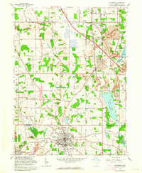 1962 Columbiana1964 Print · USGSNorth of the Mahoning and Columbiana county line during the early sixties, this region reveals a mix of industrial mining and new infrastructure. Trace family names at Mt Olivet Cem or locate former landmarks like Elser Airfield and St Marys Priory.3 unique versions available
 - 1966 Map of Salem, 1968 Print
 1966 Salem1968 Print · USGSMid-century Columbiana County centers on the industrial hubs and rail junctions of the 1960s. Researchers can trace the legacy of regional transport and industry through the Penn Central line, coal mines near Millville, and the historic Salem Airpark.3 unique versions available
End of results
Showing maps 1-5 of 5
Top cities near Leetonia
- Youngstown historical maps
- Boardman historical maps
- Austintown historical maps
- Salem historical maps
- Unity historical maps
- Struthers historical maps
See more
Frequently asked questions
- What are the different types of historical maps available for Leetonia?
- What is the oldest map of Leetonia?
- Where can I purchase historical maps of Leetonia for my home or office?
- Where can I download high-res historical maps of Leetonia?
- Are there historical topographic maps available for Leetonia?
- Is there historical aerial imagery available for Leetonia?
- Where are historical maps of Leetonia sourced from?