1900-1909 Maps of Defiance County, Ohio
Explore 5 historic maps of Defiance County from 1900-1909. These maps offer a rare glimpse into what life looked like during the 1900s — showing old roads, neighborhoods, homes, and landmarks that have changed or disappeared over time.
Whether you're researching your family's past, planning a metal detecting trip, or studying how Defiance County's landscape evolved across the 1900s, these high-resolution maps are a powerful tool for exploring the history of this region.
- Focus on a specific era: All maps on this page are from the 1900s, giving you a focused view of this time period.
- See what’s changed: Compare century-old streets, trails, and buildings to today's modern landscape using overlays and satellite layers.
- Research with precision: Use these maps for genealogy, historical research, land use analysis, or educational projects.
- View, download, or print: Maps are fully viewable online in high resolution, and can be downloaded or printed for your own records.
Start exploring Defiance County's history through authentic maps from the 1900s. This is your window into the past.
Defiance County, OH maps
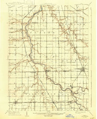
(5)- 1907 Map of Defiance, 1960 Print
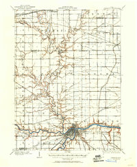 1907 Defiance1960 Print · USGSNorthwest Ohio’s river-and-rail economy is on full display at the turn of the century, centered on the strategic confluence at Defiance. Genealogists can trace family footprints in outlying settlements like Evansport, Jewell, and Ridgeville Corners.
 - 1908 Map of Ottawa, 1936 Print
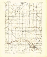 1908 Ottawa1936 Print · USGSNorthwest Ohio's agricultural landscape is seen here in the early twentieth century as a complex network of drainage ditches and competing rail lines. Genealogists can trace family roots in settlements like Glandorf, Miller City, and the rural hub of Ottawa.2 unique versions available
 - 1908 Map of Napoleon, 1942 Print
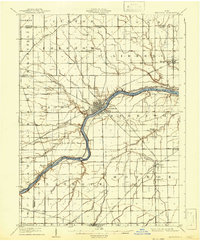 1908 Napoleon1942 Print · USGSNorthwest Ohio was a hub of steam and water transit at the turn of the century, with the Maumee River anchoring the region. Genealogists and rail historians can trace the paths of five different railroads and the historic Miami and Erie Canal through towns like Napoleon and Malinta.2 unique versions available
 - 1909 Map of Defiance, 1940 Print
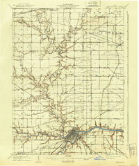 1909 Defiance1940 Print · USGSNorthwest Ohio thrives at the junction of the Maumee and Auglaize rivers in the early twentieth century. Genealogists can trace family footprints in Defiance or explore rural outposts like Evansport and the path of the Miami and Erie Canal.
 - 1909 Map of Continental, 1943 Print
 1909 Continental1943 Print · USGSNorthwest Ohio at the start of the twentieth century shows a landscape transitioning from the canal era to a rail-heavy industrial economy. Genealogists can trace family roots in Continental, Oakwood, and Cloverdale, or locate the path of the Miami and Erie Canal alongside the Auglaize River.
End of results
Showing maps 1-5 of 5
Top cities of Defiance County
Frequently asked questions
- What are the different types of historical maps available for Defiance County?
- What is the oldest map of Defiance County?
- Where can I purchase historical maps of Defiance County for my home or office?
- Where can I download high-res historical maps of Defiance County?
- Are there historical topographic maps available for Defiance County?
- Is there historical aerial imagery available for Defiance County?
- Where are historical maps of Defiance County sourced from?