1900s (20th Century) Maps of Defiance, Ohio
Explore 9 historic maps of Defiance from the 1900s (20th Century). These maps offer a rare glimpse into what life looked like during the 1900s — showing old roads, neighborhoods, homes, and landmarks that have changed or disappeared over time.
Whether you're researching your family's past, planning a metal detecting trip, or studying how Defiance's landscape evolved across the 1900s, these high-resolution maps are a powerful tool for exploring the history of this region.
- Focus on a specific era: All maps on this page are from the 1900s, giving you a focused view of this time period.
- See what’s changed: Compare century-old streets, trails, and buildings to today's modern landscape using overlays and satellite layers.
- Research with precision: Use these maps for genealogy, historical research, land use analysis, or educational projects.
- View, download, or print: Maps are fully viewable online in high resolution, and can be downloaded or printed for your own records.
Start exploring Defiance's history through authentic maps from the 1900s. This is your window into the past.
Defiance, OH maps
(9)- 1907 Map of Defiance, 1960 Print
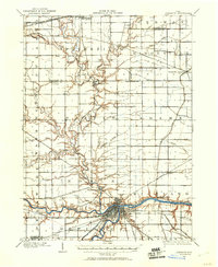 1907 Defiance1960 Print · USGSNorthwest Ohio’s river-and-rail economy is on full display at the turn of the century, centered on the strategic confluence at Defiance. Genealogists can trace family footprints in outlying settlements like Evansport, Jewell, and Ridgeville Corners.
 - 1909 Map of Defiance, 1940 Print
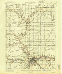 1909 Defiance1940 Print · USGSNorthwest Ohio thrives at the junction of the Maumee and Auglaize rivers in the early twentieth century. Genealogists can trace family footprints in Defiance or explore rural outposts like Evansport and the path of the Miami and Erie Canal.
 - 1909 Map of Continental, 1943 Print
 1909 Continental1943 Print · USGSNorthwest Ohio at the start of the twentieth century shows a landscape transitioning from the canal era to a rail-heavy industrial economy. Genealogists can trace family roots in Continental, Oakwood, and Cloverdale, or locate the path of the Miami and Erie Canal alongside the Auglaize River.
 - 1953 Map of Fort Wayne, 1963 Print
 1953 Fort Wayne1963 Print · USGSNortheast Indiana and its neighboring borderlands in Michigan and Ohio appear here during a peak era of rail and road expansion. Researchers can trace the massive rail networks of the Nickel Plate Road and Wabash or locate lakeside landmarks like Lake Wawasee and Clear Lake.4 unique versions available
 - 1956 Map of Fort Wayne
 1956 Fort Wayne1956 Print · USGSThe tri-state borderlands of Indiana, Michigan, and Ohio are captured here in the mid-fifties, centered on the growing industrial hub of Fort Wayne. Researchers can trace the heavy rail lines of the New York Central and Pennsylvania alongside prominent water features like Lake Wawasee and the Maumee River.2 unique versions available
 - 1959 Map of Defiance East, 1961 Print
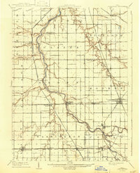
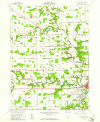
 1959 Defiance East1961 Print · USGSDefiance at the close of the fifties stands at the strategic meeting of the Maumee and Auglaize rivers. Researchers can trace the path of the Miami and Erie Canal and locate local landmarks like Defiance College, St Michaels Ch, and the Drive-in Theater.3 unique versions available
 - 1960 Map of Defiance West, 1961 Print
 1960 Defiance West1961 Print · USGSThe river-and-rail hub of Defiance is captured in the early 1960s at the vital meeting point of three major rivers and an old canal. Researchers can trace the path of the Miami and Erie Canal, locate the Banner School, or find family plots at Hill Cemetery.3 unique versions available
 - 1960 Map of Ayersville, 1961 Print
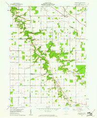 1960 Ayersville1961 Print · USGSNorthwest Ohio at the dawn of the sixties shows a landscape of steady agricultural life across three bordering counties. Genealogists can trace family roots at Taylor Cem and Mansfield Cem, or locate landmarks like Arthur and Bauer Landing Field.4 unique versions available
 - 1986 Map of Defiance, 1992 Print
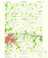
 1986 Defiance1992 Print · USGSNorthwest Ohio and Eastern Indiana appear in the late eighties as a landscape shaped by significant river confluences and rail corridors. Researchers can trace the layout of local towns and landmarks like Defiance College, Forest Hill Cem, and the path of the Norfolk and Western RR.
End of results
Showing maps 1-9 of 9
Top cities near Defiance
- Napoleon historical maps
- Bryan historical maps
- Archbold historical maps
- Paulding historical maps
- Stryker historical maps
- Continental historical maps
See more
Top neighborhoods of Defiance
Frequently asked questions
- What are the different types of historical maps available for Defiance?
- What is the oldest map of Defiance?
- Where can I purchase historical maps of Defiance for my home or office?
- Where can I download high-res historical maps of Defiance?
- Are there historical topographic maps available for Defiance?
- Is there historical aerial imagery available for Defiance?
- Where are historical maps of Defiance sourced from?