1910s Maps of Delaware County, Ohio
Explore 2 historic maps of Delaware County from the 1910s. These maps offer a rare glimpse into what life looked like during the 1910s — showing old roads, neighborhoods, homes, and landmarks that have changed or disappeared over time.
Whether you're researching your family's past, planning a metal detecting trip, or studying how Delaware County's landscape evolved across the 1910s, these high-resolution maps are a powerful tool for exploring the history of this region.
- Focus on a specific era: All maps on this page are from the 1910s, giving you a focused view of this time period.
- See what’s changed: Compare century-old streets, trails, and buildings to today's modern landscape using overlays and satellite layers.
- Research with precision: Use these maps for genealogy, historical research, land use analysis, or educational projects.
- View, download, or print: Maps are fully viewable online in high resolution, and can be downloaded or printed for your own records.
Start exploring Delaware County's history through authentic maps from the 1910s. This is your window into the past.
Delaware County, OH maps
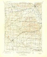
(2)- 1915 Map of Marengo, 1946 Print
 1915 Marengo1946 Print · USGSMorrow and Delaware counties are shown in detail during the heyday of the steam railroad and the one-room schoolhouse. Genealogists and historians can locate vanished local landmarks like Swamp Angel School, the County Infirmary, and the Treaty Line.
 - 1915 Map of Fredericktown, 1950 Print
 1915 Fredericktown1950 Print · USGSKnox and Morrow Counties are shown here during the height of the steam-rail era. Genealogists can locate dozens of country schoolhouses like Salem and Updike, alongside family landmarks such as Braddock Mound and the County Infirmary.
End of results
Showing maps 1-2 of 2
Top cities of Delaware County
Frequently asked questions
- What are the different types of historical maps available for Delaware County?
- What is the oldest map of Delaware County?
- Where can I purchase historical maps of Delaware County for my home or office?
- Where can I download high-res historical maps of Delaware County?
- Are there historical topographic maps available for Delaware County?
- Is there historical aerial imagery available for Delaware County?
- Where are historical maps of Delaware County sourced from?