1960s Maps of Delaware County, Ohio
Explore 14 historic maps of Delaware County from the 1960s. These maps offer a rare glimpse into what life looked like during the 1960s — showing old roads, neighborhoods, homes, and landmarks that have changed or disappeared over time.
Whether you're researching your family's past, planning a metal detecting trip, or studying how Delaware County's landscape evolved across the 1960s, these high-resolution maps are a powerful tool for exploring the history of this region.
- Focus on a specific era: All maps on this page are from the 1960s, giving you a focused view of this time period.
- See what’s changed: Compare century-old streets, trails, and buildings to today's modern landscape using overlays and satellite layers.
- Research with precision: Use these maps for genealogy, historical research, land use analysis, or educational projects.
- View, download, or print: Maps are fully viewable online in high resolution, and can be downloaded or printed for your own records.
Start exploring Delaware County's history through authentic maps from the 1960s. This is your window into the past.
Delaware County, OH maps
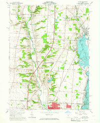
(14)- 1960 Map of Delaware, 1962 Print
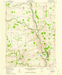
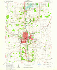 1960 Delaware1962 Print · USGSDelaware is shown in the early sixties as a thriving university town and rail hub along the Olentangy River. Genealogists and historians can trace Ohio Wesleyan University, Oak Grove Cemetery, and the settlement at Stratford.3 unique versions available
 - 1961 Map of Kilbourne, 1962 Print
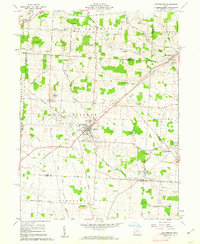
 1961 Kilbourne1962 Print · USGSDelaware and Morrow counties are shown here in the early sixties as a network of rural townships and winding creek valleys. Genealogists can locate family landmarks like Old Kilbourne Cem, Stantontown Cem, and the old County Home.4 unique versions available
 - 1961 Map of Centerburg, 1962 Print
 1961 Centerburg1962 Print · USGSKnox County is captured at the start of the 1960s, centered on the strategic rail junction at Centerburg. Genealogists and local historians can trace family plots at Houck Cem and Moreland Cem or locate old community landmarks like Milford Ch and Rich Hill.3 unique versions available
 - 1961 Map of Olive Green, 1962 Print
 1961 Olive Green1962 Print · USGSCentral Ohio farm country comes to life in the early 1960s, showing a landscape of small crossroads and creek-side settlements. Researchers can trace the path of the Pennsylvania railroad or locate rural landmarks like the Covered Bridge and Pagetown Cem.3 unique versions available
 - 1961 Map of Ostrander, 1962 Print
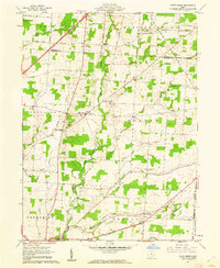
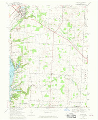
 1961 Ostrander1962 Print · USGSDelaware County at the start of the sixties shows a landscape defined by the winding Scioto River and its tributary creeks. Genealogists can trace family names through rural junctions like Brindle Corner and several pioneer burial sites, including the Old Stone Ch and Mill Creek Cem.3 unique versions available
 - 1961 Map of Waldo, 1963 Print
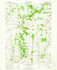
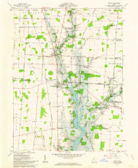 1961 Waldo1963 Print · USGSCentral Ohio during the early sixties shows a landscape in transition as the Delaware Reservoir expands through the river valleys. Genealogists can trace family footprints through numerous small burial sites like Drake Cem and Wyatt Cem or locate old community hubs at Mayfield Corners and Grange Hall.5 unique versions available
 - 1961 Map of Prospect, 1963 Print
 1961 Prospect1963 Print · USGSCentral Ohio's agricultural heartland is documented here in the early sixties, showing the vital river crossings and rail lines of Marion and Delaware Counties. Trace local genealogy and infrastructure via Prospect Cem, the Erie Railroad, and Hoskins Bridge Gaging Station.2 unique versions available
 - 1961 Map of Ashley, 1963 Print
 1961 Ashley1963 Print · USGSThe village of Ashley and its surrounding farmsteads are documented here in the early sixties, highlighting a landscape shaped by historical treaty lines and rail travel. Researchers can trace family burial sites at Ashley Union Cem and Morehouse Cem or locate the old New York Central railroad corridor.2 unique versions available
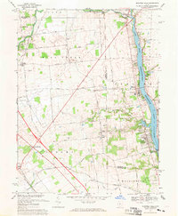
 - 1962 Map of Marion
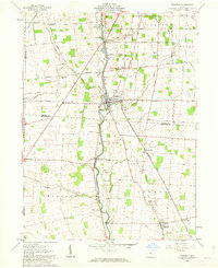
 1962 Marion1962 Print · USGSCentral Ohio during the post-war era showcases a dense network of railroad towns and emerging interstate highways. Genealogists can trace family roots in smaller settlements like Houcktown and Marseilles or locate landmarks near Indian Lake.
 - 1964 Map of Galena, 1965 Print
 1964 Galena1965 Print · USGSMid-century Delaware and Franklin Counties are captured here during a period of suburban growth and reservoir development. Genealogists and local historians can locate the Otterbein College campus and old community sites like Africa, Peachblow Cem, and the Township Meeting House.4 unique versions available
 - 1966 Map of Marion, 1968 Print
 1966 Marion1968 Print · USGSCentral Ohio in the mid-sixties is captured during a period of rapid highway expansion and industrial connectivity. Genealogists and historians can trace rail-and-river networks through towns like Marion, Urbana, and Mount Vernon, or locate landmarks such as Malabar Farm and Black Hand Rock.3 unique versions available
 - 1967 Map of Shawnee Hills, 1969 Print
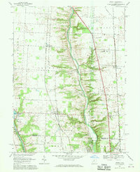
 1967 Shawnee Hills1969 Print · USGSCentral Ohio's river valleys and farming communities are captured here in the late sixties, just as the area around the O'Shaughnessy Reservoir was maturing. Researchers can locate family landmarks like Bouic Cem, trace the Penn Central rail line, or find the historic Ryan Sch in Jerome.4 unique versions available
 - 1967 Map of Sunbury, 1969 Print
 1967 Sunbury1969 Print · USGSDelaware County's rural character meets the growing reach of the capital's parklands in the late sixties. Genealogists and local historians can trace family roots through several landmarks, including Vans Valley Cem, New Bethel Ch, and the settlement at Center Village.3 unique versions available
 - 1967 Map of Powell, 1970 Print
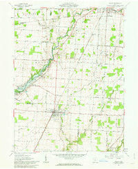
 1967 Powell1970 Print · USGSDelaware County is shown in the late 1960s as a region of growing suburban pockets and established rail corridors. Genealogists and historians can trace old community centers like Powell and Hyatts, or locate landmarks like Olentangy Caverns and Williamsville Cem.4 unique versions available
End of results
Showing maps 1-14 of 14
Top cities of Delaware County
Frequently asked questions
- What are the different types of historical maps available for Delaware County?
- What is the oldest map of Delaware County?
- Where can I purchase historical maps of Delaware County for my home or office?
- Where can I download high-res historical maps of Delaware County?
- Are there historical topographic maps available for Delaware County?
- Is there historical aerial imagery available for Delaware County?
- Where are historical maps of Delaware County sourced from?