1960s Maps of Berlin Township, Ohio
Explore 5 historic maps of Berlin Township from the 1960s. These maps offer a rare glimpse into what life looked like during the 1960s — showing old roads, neighborhoods, homes, and landmarks that have changed or disappeared over time.
Whether you're researching your family's past, planning a metal detecting trip, or studying how Berlin Township's landscape evolved across the 1960s, these high-resolution maps are a powerful tool for exploring the history of this region.
- Focus on a specific era: All maps on this page are from the 1960s, giving you a focused view of this time period.
- See what’s changed: Compare century-old streets, trails, and buildings to today's modern landscape using overlays and satellite layers.
- Research with precision: Use these maps for genealogy, historical research, land use analysis, or educational projects.
- View, download, or print: Maps are fully viewable online in high resolution, and can be downloaded or printed for your own records.
Start exploring Berlin Township's history through authentic maps from the 1960s. This is your window into the past.
Berlin Township, OH maps
(5)- 1961 Map of Toledo
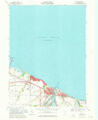
 1961 Toledo1961 Print · USGSThe western basin of Lake Erie and the industrial heart of Northern Ohio are captured here during the post-war era. Researchers can trace historical rail lines like the New York Central or locate landmarks like the Erie Ordnance Depot and Pelee Island.
 - 1969 Map of Huron, 1971 Print
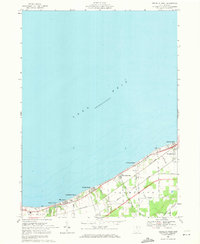
 1969 Huron1971 Print · USGSHuron and the Erie county coast are shown here in the late sixties as the lakefront transitioned from industrial rail hub to an expanding college town. Genealogists and researchers can trace the growth of Huron and Oberlin Beach, locating landmarks like Restlawn Memorial Park and the Fireland Campus.3 unique versions available
 - 1969 Map of Vermilion West, 1971 Print
 1969 Vermilion West1971 Print · USGSLake Erie's southern shore in the late sixties is lined with distinct beach communities and vital rail corridors. Genealogists and local historians can trace the development of Vermilion and summer colonies like Ruggles Beach, Heidelberg Beach, and Bluebird Beach.2 unique versions available
 - 1969 Map of Berlin Heights, 1971 Print
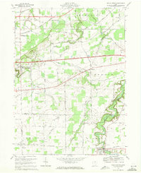 1969 Berlin Heights1971 Print · USGSThe Firelands region of northern Ohio is captured here in the late sixties as agricultural roots met the burgeoning interstate era. Researchers can trace local lineage through Peakes Cem, follow the rail lines at Berlin Heights Station, or locate the Townsend Sch.3 unique versions available
 - 1969 Map of Milan, 1971 Print
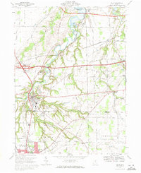 1969 Milan1971 Print · USGSSettled along the winding Huron River in the late 1960s, this portion of Erie and Huron Counties shows a landscape defined by river valleys and rail lines. Researchers can find Scotts Cemetery, the Friends Church, and old stops at Shinrock and Avery.2 unique versions available
End of results
Showing maps 1-5 of 5
Top cities near Berlin Township
- Lorain historical maps
- Sandusky historical maps
- Norwalk historical maps
- Vermilion historical maps
- Milan historical maps
- Florence historical maps
See more
Top neighborhoods of Berlin Township
- Berlin Heights Station historical maps
- Oberlin Beach historical maps
- Berlinville historical maps
- Ceylon historical maps
- Ogontz historical maps
- Ruggles Beach historical maps
See more
Frequently asked questions
- What are the different types of historical maps available for Berlin Township?
- What is the oldest map of Berlin Township?
- Where can I purchase historical maps of Berlin Township for my home or office?
- Where can I download high-res historical maps of Berlin Township?
- Are there historical topographic maps available for Berlin Township?
- Is there historical aerial imagery available for Berlin Township?
- Where are historical maps of Berlin Township sourced from?