Old Maps of Erie County, Ohio for Hiking & Exploration
Hike through history with 110 historic maps of Erie County. Explore old trails, ghost towns, and forgotten backroads — perfect for outdoor adventurers and local explorers.
- Rediscover forgotten places: Map out old mining camps, roads, and footpaths that no longer exist on modern maps.
- Layer with modern tools: Combine with LiDAR or satellite views to plan hikes through historical terrain.
- Made for exploration: Popular among hikers, overlanders, and local history lovers.
Use these maps to find adventure and explore the hidden past of Erie County.
Erie County, OH maps
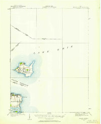
(110)- 1901 Map of Put-In-Bay, 1958 Print
 1901 Put-In-Bay1958 Print · USGSOttawa County's shoreline and the famous Lake Erie islands are captured at the start of the twentieth century, before modern development reshaped the coast. Genealogists and historians can trace the rail lines of the Lakeside and Sandusky Line and locate early settlements like Gypsum and St. George.
 - 1901 Map of Bellevue, 1958 Print
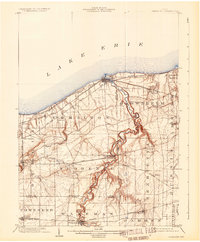
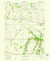
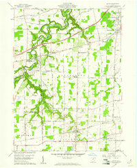
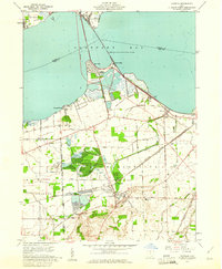
 1901 Bellevue1958 Print · USGSAcross the marshy lowlands and limestone springs of Erie and Sandusky counties at the turn of the century, a massive railroad network dominates the landscape. Genealogists can trace family footprints in Clyde and Bellevue or locate vanished rail stops at Thames and Parkertown.
 - 1903 Map of Bellevue
 1903 Bellevue1903 Print · USGSNear the dawn of the twentieth century, the junction of Erie and Sandusky counties was a bustling corridor of rail and water transport. Genealogists and historians can trace the early footprints of Bellevue and Clyde, or find specific local landmarks like the Blue Hole and the Connecticut Western Reserve Boundary Line.5 unique versions available
 - 1903 Map of Vermilion, 1932 Print
 1903 Vermilion1932 Print · USGSThe Lake Erie shoreline in the early twentieth century served as a vital transit hub where rail lines and electric cars converged on the coast. Genealogists and local historians can trace the early layouts of Vermilion, Wakeman, and Birmingham, or locate the specific placement of the Quarry and numerous creek-side homesteads.2 unique versions available
 - 1903 Map of Put In Bay, 1939 Print
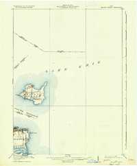
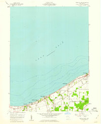
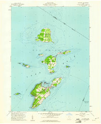
 1903 Put In Bay1939 Print · USGSOttawa County's shoreline and islands are captured in the early twentieth century, showing a world of maritime transit and early rail. Genealogists can trace the early layout of Port Clinton and the distinct settlements of Put in Bay, Gypsum, and Lakeside.
 - 1904 Map of Sandusky, 1941 Print
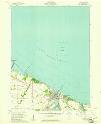
 1904 Sandusky1941 Print · USGSThe Lake Erie shoreline at the turn of the century shows a bustling rail-and-port economy centered on Sandusky and the Huron River. Researchers can trace early infrastructure like the Electric Line and vanished landmarks such as the State Soldiers Home.3 unique versions available
 - 1916 Map of Kelleys Island, 1958 Print
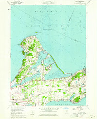
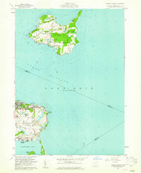
 1916 Kelleys Island1958 Print · USGSLake Erie's western islands and the Marblehead peninsula are shown here as they appeared during the early twentieth century. Genealogists and local historians can trace the foundations of the island community through sites like Estes School or follow the path of the Northwestern Electric line.
 - 1919 Map of Kelleys Island, 1936 Print
 1919 Kelleys Island1936 Print · USGSLake Erie's coastal communities and islands are captured in the late nineteen-teens, during the height of the region's quarrying and port activity. Genealogists and local historians can trace school sites like St Michael School or explore the early layouts of Lakeside and Marblehead.
 - 1956 Map of Toledo, 1968 Print
 1956 Toledo1968 Print · USGSNorthwest Ohio and the Lake Erie shoreline are shown in detail during the late fifties, showcasing a landscape of heavy industry, railroads, and island communities. Genealogists and historians can trace rail networks like the Chesapeake & Ohio RR or locate landmarks such as the Erie Proving Ground and Kelleys Island.4 unique versions available
 - 1957 Map of Vickery, 1960 Print
 1957 Vickery1960 Print · USGSCoastal Sandusky Bay was a mix of marshy wetlands and emerging industry in the late fifties. Genealogists and historians can trace family roots through markers like Township Sch, Riley Grange, and the waterfront at Whites Landing.
 - 1959 Map of Kimball, 1960 Print
 1959 Kimball1960 Print · USGSErie County at the end of the fifties reveals a landscape shaped by military industry and the arrival of the modern turnpike. Researchers can trace family-named landmarks and old church sites like St Johns Ch, Union Corner Cem, and the rail junction at Kimball.
 - 1959 Map of Milan, 1960 Print
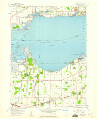
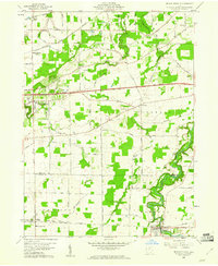
 1959 Milan1960 Print · USGSMilan and the surrounding Erie County townships are captured here in the late fifties, just as the turnpike began to reshape the rural landscape. Researchers can trace family history through numerous landmarks like Scotts Cem or locate old rail stops along the New York Central and New York Chicago and St Louis lines.
 - 1959 Map of Sandusky, 1960 Print
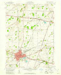
 1959 Sandusky1960 Print · USGSSandusky thrived as a hub of rail and lake commerce in the late fifties, from its busy Turning Basin to the vast Plum Brook Ordnance Works. Local researchers can trace family plots at Sandusky Cemetery or locate old neighborhood landmarks like Barker Sch and St Joseph Ch.
 - 1959 Map of Bellevue, 1960 Print
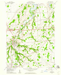
 1959 Bellevue1960 Print · USGSBellevue stands at the four-county junction of Erie, Huron, Sandusky, and Seneca during the late 1950s expansion. Genealogists and local historians can trace school locations like Ridge Sch and Shumaker Sch alongside the tracks of the Pennsylvania RR.
 - 1959 Map of Berlin Heights, 1960 Print
 1959 Berlin Heights1960 Print · USGSNorth-central Ohio is captured in the late fifties, showing the interplay between the new Ohio Turnpike and historic farm-to-market rail lines. Local historians can trace family roots through numerous burial sites like Maple Grove Cem and Poyers Cem or locate old schoolhouse sites like Townsend Sch.2 unique versions available
 - 1959 Map of Vermilion East, 1960 Print
 1959 Vermilion East1960 Print · USGSThe Lake Erie shoreline and the Vermilion River valley are captured here in the late fifties, showing the area's transition into a modern transit corridor. Genealogists and local historians can locate early landmarks like Brownhelm Cem and the Brownhelm (Station) along the New York Central tracks.2 unique versions available
 - 1959 Map of Vermilion West, 1960 Print
 1959 Vermilion West1960 Print · USGSCoastal Erie County comes alive in this late fifties study of the lakefront's shifting character between industrial rail lines and seasonal resorts. Researchers can trace family-named roads like Poorman Road alongside established beach communities like Mitiwanga and Orchard Beach.
 - 1959 Map of Kipton, 1961 Print
 1959 Kipton1961 Print · USGSLorain County in the late fifties shows a landscape of traditional farming and growing industry, from the quarrying district of South Amherst to the quiet village of Kipton. Genealogists and researchers can trace local landmarks like Henrietta Cem, the Nickel Plate Road, and the path of the Vermilion River.
 - 1959 Map of Huron, 1961 Print
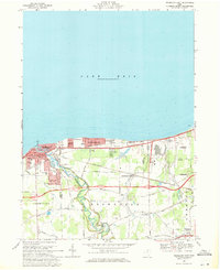
 1959 Huron1961 Print · USGSThe shoreline of Lake Erie in the late fifties was a stretch of evolving lakeside communities and industrial rail activity. Genealogists and historians can trace the early layouts of Rye Beach, Chaska Beach, and Huron, alongside the busy New York Central rail lines.
 - 1959 Map of Gypsum, 1961 Print
 1959 Gypsum1961 Print · USGSThe Lake Erie shoreline in the late fifties shows a fascinating overlap of limestone industry and growing vacation communities. Local historians can trace the massive Marblehead Quarry operations alongside established settlements like Lakeside and Danbury.
 - 1959 Map of Put-In-Bay, 1961 Print
 1959 Put-In-Bay1961 Print · USGSThe Lake Erie islands in the late fifties show a thriving archipelago defined by vineyards, ferry travel, and maritime heritage. Genealogists and local historians can trace family locations along Fox Road or near St Pauls Ch, and locate landmarks like the Perry Nat Monument.
 - 1959 Map of Kelleys Island, 1961 Print
 1959 Kelleys Island1961 Print · USGSThe Lake Erie islands and Marblehead peninsula are shown here in the late fifties, featuring a mix of resort life and heavy industry. Genealogists and historians can locate the Confederate Cem on Johnson Island, the iconic Marblehead Lighthouse, and the Glacial Grooves State Memorial.2 unique versions available
 - 1959 Map of Castalia, 1965 Print
 1959 Castalia1965 Print · USGSCoastal Erie County and the Sandusky Bay shoreline are captured here in the late fifties as rail lines and industrial quarries defined the local economy. Genealogists and researchers can locate the Trinity Ch, trace the Pennsylvania Railroad, or find the Blue Hole and Township Sch.
 - 1961 Map of Toledo
 1961 Toledo1961 Print · USGSThe western basin of Lake Erie and the industrial heart of Northern Ohio are captured here during the post-war era. Researchers can trace historical rail lines like the New York Central or locate landmarks like the Erie Ordnance Depot and Pelee Island.
 - 1969 Map of Vermilion East, 1971 Print
 1969 Vermilion East1971 Print · USGSThe Lake Erie shoreline at Vermilion is captured here during a period of suburban expansion and industrial growth. Researchers can trace the heritage of the Connecticut Western Reserve through local landmarks like Brownhelm Station, St Marys Sch, and the Rugby Cem.3 unique versions available
Showing maps 1-25 of 110
Top cities of Erie County
Frequently asked questions
- What are the different types of historical maps available for Erie County?
- What is the oldest map of Erie County?
- Where can I purchase historical maps of Erie County for my home or office?
- Where can I download high-res historical maps of Erie County?
- Are there historical topographic maps available for Erie County?
- Is there historical aerial imagery available for Erie County?
- Where are historical maps of Erie County sourced from?